You are here: Home > Network List > TA - USArray Transportable Network (new EarthScope stations) Stations List
> Station H16K Elim, AK, USA > Earthquake Result Viewer
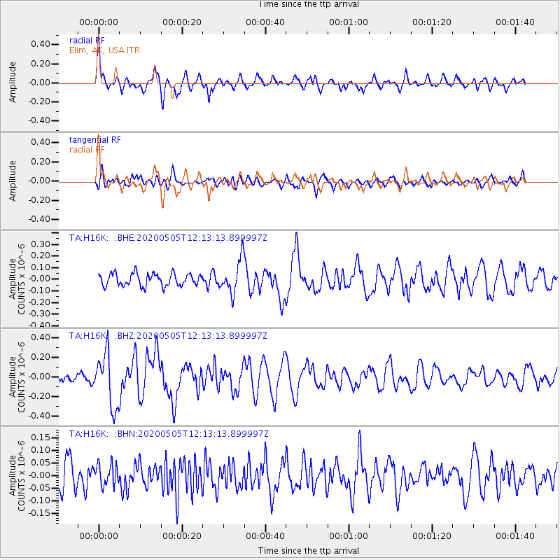
H16K Elim, AK, USA - Earthquake Result Viewer
*The percent match for this event was below the threshold and hence no stack was calculated.
| Earthquake location: |
Near Coast Of Guatemala |
| Earthquake latitude/longitude: |
13.3/-91.1 |
| Earthquake time(UTC): |
2020/05/05 (126) 12:02:32 GMT |
| Earthquake Depth: |
8.0 km |
| Earthquake Magnitude: |
5.5 Mww |
| Earthquake Catalog/Contributor: |
NEIC PDE/us |
|
| Network: |
TA USArray Transportable Network (new EarthScope stations) |
| Station: |
H16K Elim, AK, USA |
| Lat/Lon: |
64.64 N/162.24 W |
| Elevation: |
216 m |
|
| Distance: |
70.0 deg |
| Az: |
334.303 deg |
| Baz: |
101.416 deg |
| Ray Param: |
$rayparam |
*The percent match for this event was below the threshold and hence was not used in the summary stack. |
|
| Radial Match: |
74.77235 % |
| Radial Bump: |
400 |
| Transverse Match: |
63.115425 % |
| Transverse Bump: |
400 |
| SOD ConfigId: |
21166931 |
| Insert Time: |
2020-06-02 12:28:05.970 +0000 |
| GWidth: |
2.5 |
| Max Bumps: |
400 |
| Tol: |
0.001 |
|
Signal To Noise
| Channel | StoN | STA | LTA |
| TA:H16K: :BHZ:20200505T12:13:13.899997Z | 6.866149 | 2.8200748E-7 | 4.1072145E-8 |
| TA:H16K: :BHN:20200505T12:13:13.899997Z | 0.961913 | 4.1528647E-8 | 4.3172978E-8 |
| TA:H16K: :BHE:20200505T12:13:13.899997Z | 2.8347445 | 1.4836174E-7 | 5.2336897E-8 |
| Arrivals |
| Ps | |
| PpPs | |
| PsPs/PpSs | |


