You are here: Home > Network List > TA - USArray Transportable Network (new EarthScope stations) Stations List
> Station O17K Koliganek, Bristol Bay, AK, USA > Earthquake Result Viewer
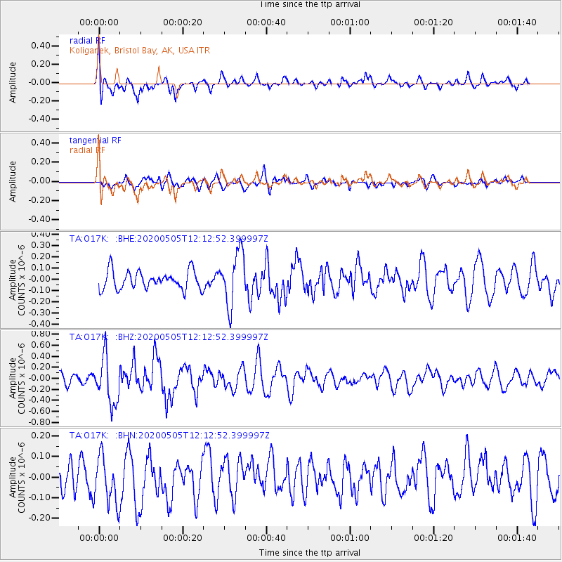
O17K Koliganek, Bristol Bay, AK, USA - Earthquake Result Viewer
*The percent match for this event was below the threshold and hence no stack was calculated.
| Earthquake location: |
Near Coast Of Guatemala |
| Earthquake latitude/longitude: |
13.3/-91.1 |
| Earthquake time(UTC): |
2020/05/05 (126) 12:02:32 GMT |
| Earthquake Depth: |
8.0 km |
| Earthquake Magnitude: |
5.5 Mww |
| Earthquake Catalog/Contributor: |
NEIC PDE/us |
|
| Network: |
TA USArray Transportable Network (new EarthScope stations) |
| Station: |
O17K Koliganek, Bristol Bay, AK, USA |
| Lat/Lon: |
59.77 N/157.09 W |
| Elevation: |
156 m |
|
| Distance: |
66.6 deg |
| Az: |
329.762 deg |
| Baz: |
104.285 deg |
| Ray Param: |
$rayparam |
*The percent match for this event was below the threshold and hence was not used in the summary stack. |
|
| Radial Match: |
66.08886 % |
| Radial Bump: |
400 |
| Transverse Match: |
46.550243 % |
| Transverse Bump: |
399 |
| SOD ConfigId: |
21166931 |
| Insert Time: |
2020-06-02 12:29:10.520 +0000 |
| GWidth: |
2.5 |
| Max Bumps: |
400 |
| Tol: |
0.001 |
|
Signal To Noise
| Channel | StoN | STA | LTA |
| TA:O17K: :BHZ:20200505T12:12:52.399997Z | 3.4285307 | 4.3352676E-7 | 1.264468E-7 |
| TA:O17K: :BHN:20200505T12:12:52.399997Z | 1.274567 | 1.1733279E-7 | 9.205698E-8 |
| TA:O17K: :BHE:20200505T12:12:52.399997Z | 2.954416 | 2.3974582E-7 | 8.114829E-8 |
| Arrivals |
| Ps | |
| PpPs | |
| PsPs/PpSs | |


