You are here: Home > Network List > US - United States National Seismic Network Stations List
> Station AHID Auburn Hatchery, Idaho, USA > Earthquake Result Viewer
AHID Auburn Hatchery, Idaho, USA - Earthquake Result Viewer
| Earthquake location: |
Near Islands, Aleutian Islands |
| Earthquake latitude/longitude: |
54.0/170.9 |
| Earthquake time(UTC): |
2017/06/02 (153) 22:24:47 GMT |
| Earthquake Depth: |
8.2 km |
| Earthquake Magnitude: |
6.8 Mww |
| Earthquake Catalog/Contributor: |
NEIC PDE/us |
|
| Network: |
US United States National Seismic Network |
| Station: |
AHID Auburn Hatchery, Idaho, USA |
| Lat/Lon: |
42.77 N/111.10 W |
| Elevation: |
1960 m |
|
| Distance: |
50.5 deg |
| Az: |
69.076 deg |
| Baz: |
311.557 deg |
| Ray Param: |
0.068049684 |
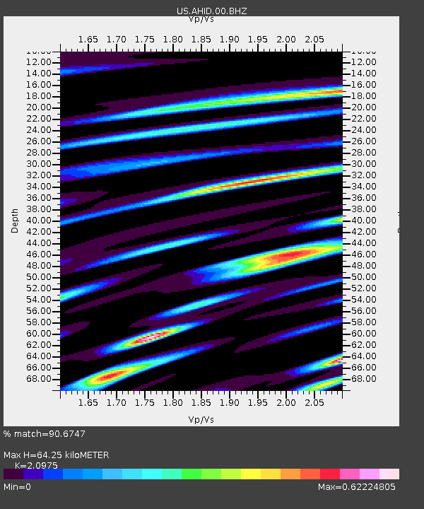
| Estimated Moho Depth: |
64.25 km |
| Estimated Crust Vp/Vs: |
2.10 |
| Assumed Crust Vp: |
6.207 km/s |
| Estimated Crust Vs: |
2.959 km/s |
| Estimated Crust Poisson's Ratio: |
0.35 |
|
| Radial Match: |
90.6747 % |
| Radial Bump: |
400 |
| Transverse Match: |
82.22438 % |
| Transverse Bump: |
400 |
| SOD ConfigId: |
2140511 |
| Insert Time: |
2017-06-16 14:26:52.612 +0000 |
| GWidth: |
2.5 |
| Max Bumps: |
400 |
| Tol: |
0.001 |
|
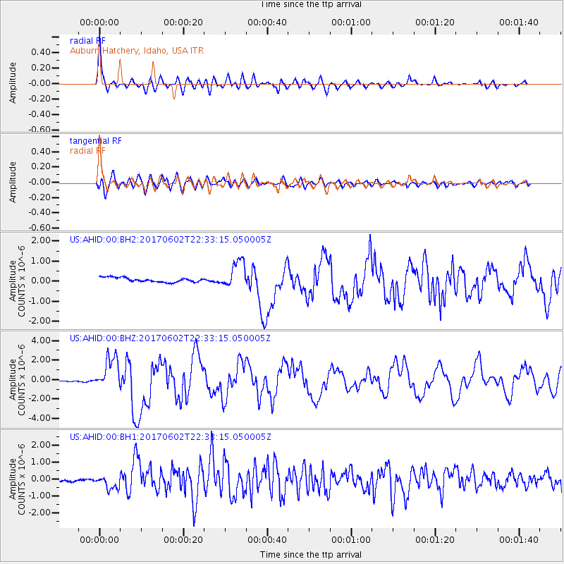
Signal To Noise
| Channel | StoN | STA | LTA |
| US:AHID:00:BHZ:20170602T22:33:15.050005Z | 35.63761 | 1.7431904E-6 | 4.8914345E-8 |
| US:AHID:00:BH1:20170602T22:33:15.050005Z | 7.427312 | 3.5646832E-7 | 4.7994256E-8 |
| US:AHID:00:BH2:20170602T22:33:15.050005Z | 6.3179016 | 6.981798E-7 | 1.10508175E-7 |
| Arrivals |
| Ps | 12 SECOND |
| PpPs | 31 SECOND |
| PsPs/PpSs | 43 SECOND |


