You are here: Home > Network List > US - United States National Seismic Network Stations List
> Station DGMT Dagmar, Montana, USA > Earthquake Result Viewer
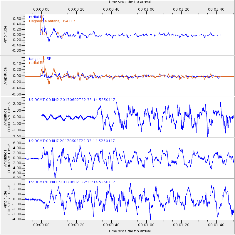
DGMT Dagmar, Montana, USA - Earthquake Result Viewer
*The percent match for this event was below the threshold and hence no stack was calculated.
| Earthquake location: |
Near Islands, Aleutian Islands |
| Earthquake latitude/longitude: |
54.0/170.9 |
| Earthquake time(UTC): |
2017/06/02 (153) 22:24:47 GMT |
| Earthquake Depth: |
8.2 km |
| Earthquake Magnitude: |
6.8 Mww |
| Earthquake Catalog/Contributor: |
NEIC PDE/us |
|
| Network: |
US United States National Seismic Network |
| Station: |
DGMT Dagmar, Montana, USA |
| Lat/Lon: |
48.47 N/104.20 W |
| Elevation: |
0.0 m |
|
| Distance: |
50.4 deg |
| Az: |
59.367 deg |
| Baz: |
310.291 deg |
| Ray Param: |
$rayparam |
*The percent match for this event was below the threshold and hence was not used in the summary stack. |
|
| Radial Match: |
93.975105 % |
| Radial Bump: |
400 |
| Transverse Match: |
82.07873 % |
| Transverse Bump: |
400 |
| SOD ConfigId: |
2140511 |
| Insert Time: |
2017-06-16 14:27:26.833 +0000 |
| GWidth: |
2.5 |
| Max Bumps: |
400 |
| Tol: |
0.001 |
|
Signal To Noise
| Channel | StoN | STA | LTA |
| US:DGMT:00:BHZ:20170602T22:33:14.525011Z | 22.938822 | 2.3869495E-6 | 1.040572E-7 |
| US:DGMT:00:BH1:20170602T22:33:14.525011Z | 5.7316756 | 9.112838E-7 | 1.5899082E-7 |
| US:DGMT:00:BH2:20170602T22:33:14.525011Z | 3.9319315 | 8.5454366E-7 | 2.1733432E-7 |
| Arrivals |
| Ps | |
| PpPs | |
| PsPs/PpSs | |


