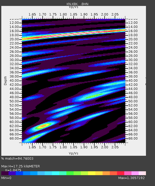
KBK KN.KBK - Earthquake Result Viewer

Earthquake location: Southern Sumatra, Indonesia
Earthquake latitude/longitude: -1.6/99.6
Earthquake time(UTC): 2005/04/10 (100) 10:29:11 GMT
Earthquake Depth: 19 km
Earthquake Magnitude: 6.4 MB, 6.7 MS, 6.7 MW, 6.6 MW
Earthquake Catalog/Contributor: WHDF/NEIC
Network: KN Kyrgyz Seismic Telemetry Network
Station: KBK KN.KBK
Lat/Lon: 42.66 N/74.95 E
Elevation: 1760 m
Distance: 49.4 deg
Az: 336.082 deg
Baz: 146.677 deg
Ray Param: 0.0687085
Estimated Moho Depth: 17.25 km
Estimated Crust Vp/Vs: 1.85
Assumed Crust Vp: 6.306 km/s
Estimated Crust Vs: 3.413 km/s
Estimated Crust Poisson's Ratio: 0.29
Radial Match: 94.76003 %
Radial Bump: 400
Transverse Match: 93.44194 %
Transverse Bump: 400
SOD ConfigId: 2459
Insert Time: 2010-03-08 20:16:51.405 +0000
GWidth: 2.5
Max Bumps: 400
Tol: 0.001

Signal To Noise

ChannelStoNSTALTA
KN:KBK: :BHN:20050410T10:37:28.725007Z3.95940289.57401E-72.418044E-7
KN:KBK: :BHE:20050410T10:37:28.725007Z5.94064248.260359E-71.3904824E-7
KN:KBK: :BHZ:20050410T10:37:28.725007Z14.3280012.5814288E-61.8016671E-7
Arrivals
Ps2.4 SECOND
PpPs7.4 SECOND
PsPs/PpSs9.8 SECOND