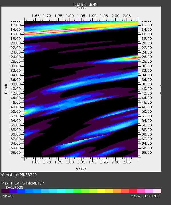
KBK KN.KBK - Earthquake Result Viewer
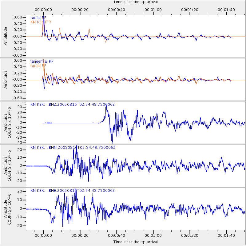
Earthquake location: Near East Coast Of Honshu, Japan
Earthquake latitude/longitude: 38.3/142.0
Earthquake time(UTC): 2005/08/16 (228) 02:46:28 GMT
Earthquake Depth: 36 km
Earthquake Magnitude: 6.5 MB, 6.8 MS, 7.2 MW, 7.1 MW
Earthquake Catalog/Contributor: WHDF/NEIC
Network: KN Kyrgyz Seismic Telemetry Network
Station: KBK KN.KBK
Lat/Lon: 42.66 N/74.95 E
Elevation: 1760 m
Distance: 50.0 deg
Az: 297.533 deg
Baz: 71.099 deg
Ray Param: 0.06825752
Estimated Moho Depth: 14.75 km
Estimated Crust Vp/Vs: 1.70
Assumed Crust Vp: 6.306 km/s
Estimated Crust Vs: 3.704 km/s
Estimated Crust Poisson's Ratio: 0.24
Radial Match: 95.65749 %
Radial Bump: 400
Transverse Match: 92.39463 %
Transverse Bump: 400
SOD ConfigId: 2475
Insert Time: 2010-03-08 20:17:07.014 +0000
GWidth: 2.5
Max Bumps: 400
Tol: 0.001

Signal To Noise

ChannelStoNSTALTA
KN:KBK: :BHN:20050816T02:54:48.750006Z25.3233412.355568E-69.301964E-8
KN:KBK: :BHE:20050816T02:54:48.750006Z40.4439055.495361E-61.3587612E-7
KN:KBK: :BHZ:20050816T02:54:48.750006Z117.072451.26451705E-51.08011506E-7
Arrivals
Ps1.7 SECOND
PpPs6.0 SECOND
PsPs/PpSs7.7 SECOND