You are here: Home > Network List > US - United States National Seismic Network Stations List
> Station HWUT Hardware Ranch, Cache County, Utah, USA > Earthquake Result Viewer
HWUT Hardware Ranch, Cache County, Utah, USA - Earthquake Result Viewer
| Earthquake location: |
Near Islands, Aleutian Islands |
| Earthquake latitude/longitude: |
54.0/170.9 |
| Earthquake time(UTC): |
2017/06/02 (153) 22:24:47 GMT |
| Earthquake Depth: |
8.2 km |
| Earthquake Magnitude: |
6.8 Mww |
| Earthquake Catalog/Contributor: |
NEIC PDE/us |
|
| Network: |
US United States National Seismic Network |
| Station: |
HWUT Hardware Ranch, Cache County, Utah, USA |
| Lat/Lon: |
41.61 N/111.57 W |
| Elevation: |
1830 m |
|
| Distance: |
51.0 deg |
| Az: |
70.488 deg |
| Baz: |
312.14 deg |
| Ray Param: |
0.067709655 |
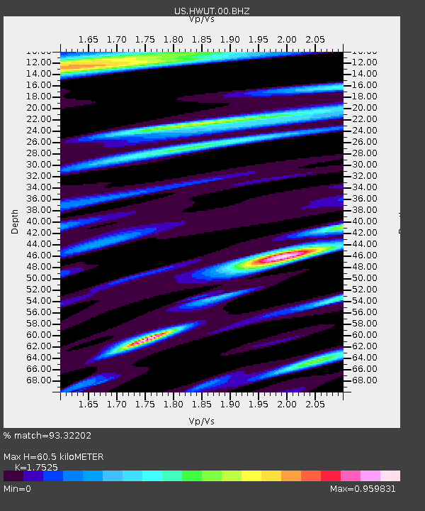
| Estimated Moho Depth: |
60.5 km |
| Estimated Crust Vp/Vs: |
1.75 |
| Assumed Crust Vp: |
6.155 km/s |
| Estimated Crust Vs: |
3.512 km/s |
| Estimated Crust Poisson's Ratio: |
0.26 |
|
| Radial Match: |
93.32202 % |
| Radial Bump: |
400 |
| Transverse Match: |
85.7953 % |
| Transverse Bump: |
400 |
| SOD ConfigId: |
2140511 |
| Insert Time: |
2017-06-16 14:28:06.470 +0000 |
| GWidth: |
2.5 |
| Max Bumps: |
400 |
| Tol: |
0.001 |
|

Signal To Noise
| Channel | StoN | STA | LTA |
| US:HWUT:00:BHZ:20170602T22:33:18.925005Z | 25.911036 | 2.111271E-6 | 8.148153E-8 |
| US:HWUT:00:BH1:20170602T22:33:18.925005Z | 19.575645 | 7.291632E-7 | 3.724849E-8 |
| US:HWUT:00:BH2:20170602T22:33:18.925005Z | 13.40622 | 7.3768916E-7 | 5.5025886E-8 |
| Arrivals |
| Ps | 7.8 SECOND |
| PpPs | 26 SECOND |
| PsPs/PpSs | 33 SECOND |


