You are here: Home > Network List > KN - Kyrgyz Seismic Telemetry Network Stations List
> Station KBK KN.KBK > Earthquake Result Viewer
KBK KN.KBK - Earthquake Result Viewer
| Earthquake location: |
South Of Mariana Islands |
| Earthquake latitude/longitude: |
10.5/145.7 |
| Earthquake time(UTC): |
2007/09/30 (273) 02:08:30 GMT |
| Earthquake Depth: |
14 km |
| Earthquake Magnitude: |
6.4 MB, 7.1 MS, 6.9 MW, 6.9 MW |
| Earthquake Catalog/Contributor: |
WHDF/NEIC |
|
| Network: |
KN Kyrgyz Seismic Telemetry Network |
| Station: |
KBK KN.KBK |
| Lat/Lon: |
42.66 N/74.95 E |
| Elevation: |
1760 m |
|
| Distance: |
68.9 deg |
| Az: |
311.686 deg |
| Baz: |
95.274 deg |
| Ray Param: |
0.056021392 |
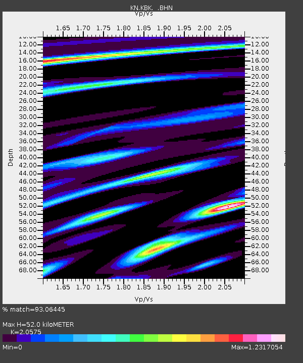
| Estimated Moho Depth: |
52.0 km |
| Estimated Crust Vp/Vs: |
2.06 |
| Assumed Crust Vp: |
6.306 km/s |
| Estimated Crust Vs: |
3.065 km/s |
| Estimated Crust Poisson's Ratio: |
0.35 |
|
| Radial Match: |
93.06445 % |
| Radial Bump: |
400 |
| Transverse Match: |
83.62671 % |
| Transverse Bump: |
400 |
| SOD ConfigId: |
2564 |
| Insert Time: |
2010-03-08 20:17:48.626 +0000 |
| GWidth: |
2.5 |
| Max Bumps: |
400 |
| Tol: |
0.001 |
|

Signal To Noise
| Channel | StoN | STA | LTA |
| KN:KBK: :BHN:20070930T02:19:02.899004Z | 3.1102753 | 2.2997902E-7 | 7.394169E-8 |
| KN:KBK: :BHE:20070930T02:19:02.899004Z | 5.315308 | 2.1425426E-7 | 4.0308908E-8 |
| KN:KBK: :BHZ:20070930T02:19:02.899004Z | 9.68751 | 5.59874E-7 | 5.779339E-8 |
| Arrivals |
| Ps | 9.0 SECOND |
| PpPs | 24 SECOND |
| PsPs/PpSs | 33 SECOND |


