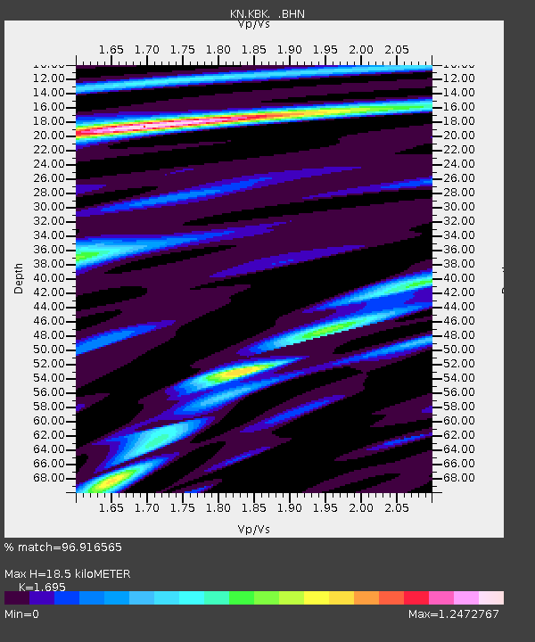
KBK KN.KBK - Earthquake Result Viewer
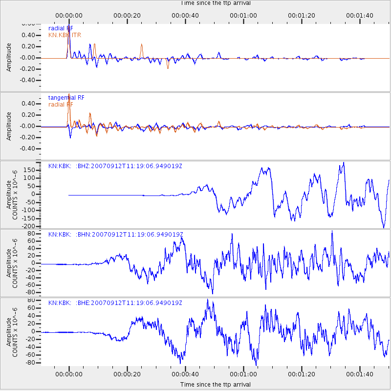
Earthquake location: Southern Sumatra, Indonesia
Earthquake latitude/longitude: -4.4/101.4
Earthquake time(UTC): 2007/09/12 (255) 11:10:26 GMT
Earthquake Depth: 34 km
Earthquake Magnitude: 6.9 MB, 8.5 MS, 8.4 MW, 8.0 ME
Earthquake Catalog/Contributor: WHDF/NEIC
Network: KN Kyrgyz Seismic Telemetry Network
Station: KBK KN.KBK
Lat/Lon: 42.66 N/74.95 E
Elevation: 1760 m
Distance: 52.6 deg
Az: 335.61 deg
Baz: 146.075 deg
Ray Param: 0.066566125
Estimated Moho Depth: 18.5 km
Estimated Crust Vp/Vs: 1.70
Assumed Crust Vp: 6.306 km/s
Estimated Crust Vs: 3.72 km/s
Estimated Crust Poisson's Ratio: 0.23
Radial Match: 96.916565 %
Radial Bump: 400
Transverse Match: 93.95473 %
Transverse Bump: 400
SOD ConfigId: 2564
Insert Time: 2010-03-08 20:18:17.293 +0000
GWidth: 2.5
Max Bumps: 400
Tol: 0.001

Signal To Noise

ChannelStoNSTALTA
KN:KBK: :BHN:20070912T11:19:06.949019Z5.69126131.1470391E-62.0154393E-7
KN:KBK: :BHE:20070912T11:19:06.949019Z3.20453727.422759E-72.316328E-7
KN:KBK: :BHZ:20070912T11:19:06.949019Z6.2055152.0833647E-63.3572795E-7
Arrivals
Ps2.2 SECOND
PpPs7.5 SECOND
PsPs/PpSs9.6 SECOND