KBK KN.KBK - Earthquake Result Viewer
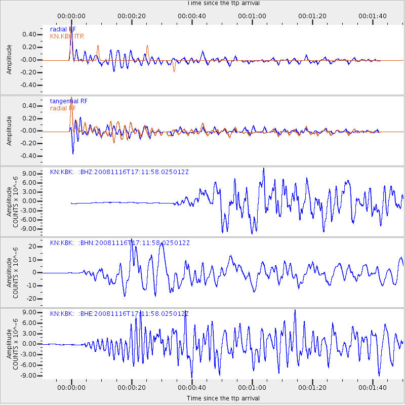
Earthquake location: Minahassa Peninsula, Sulawesi
Earthquake latitude/longitude: 1.3/122.1
Earthquake time(UTC): 2008/11/16 (321) 17:02:32 GMT
Earthquake Depth: 30 km
Earthquake Magnitude: 6.5 MB, 7.0 MS, 7.3 MW, 7.3 MW
Earthquake Catalog/Contributor: WHDF/NEIC
Network: KN Kyrgyz Seismic Telemetry Network
Station: KBK KN.KBK
Lat/Lon: 42.66 N/74.95 E
Elevation: 1760 m
Distance: 58.9 deg
Az: 320.837 deg
Baz: 121.142 deg
Ray Param: 0.062493015
Estimated Moho Depth: 46.25 km
Estimated Crust Vp/Vs: 1.81
Assumed Crust Vp: 6.306 km/s
Estimated Crust Vs: 3.489 km/s
Estimated Crust Poisson's Ratio: 0.28
Radial Match: 93.527695 %
Radial Bump: 400
Transverse Match: 86.984825 %
Transverse Bump: 400
SOD ConfigId: 2658
Insert Time: 2010-03-08 20:19:12.907 +0000
GWidth: 2.5
Max Bumps: 400
Tol: 0.001

Signal To Noise

ChannelStoNSTALTA
KN:KBK: :BHN:20081116T17:11:58.025012Z6.32369336.831694E-71.0803329E-7
KN:KBK: :BHE:20081116T17:11:58.025012Z3.82322342.0848915E-75.45323E-8
KN:KBK: :BHZ:20081116T17:11:58.025012Z1.79781252.2962338E-71.2772377E-7
Arrivals
Ps6.2 SECOND
PpPs20 SECOND
PsPs/PpSs26 SECOND