You are here: Home > Network List > UU - University of Utah Regional Network Stations List
> Station FORU South Mineral Mountains, UT, USA > Earthquake Result Viewer
FORU South Mineral Mountains, UT, USA - Earthquake Result Viewer
| Earthquake location: |
Near Islands, Aleutian Islands |
| Earthquake latitude/longitude: |
54.0/170.9 |
| Earthquake time(UTC): |
2017/06/02 (153) 22:24:47 GMT |
| Earthquake Depth: |
8.2 km |
| Earthquake Magnitude: |
6.8 Mww |
| Earthquake Catalog/Contributor: |
NEIC PDE/us |
|
| Network: |
UU University of Utah Regional Network |
| Station: |
FORU South Mineral Mountains, UT, USA |
| Lat/Lon: |
38.46 N/112.86 W |
| Elevation: |
1840 m |
|
| Distance: |
52.4 deg |
| Az: |
74.287 deg |
| Baz: |
313.666 deg |
| Ray Param: |
0.0667985 |
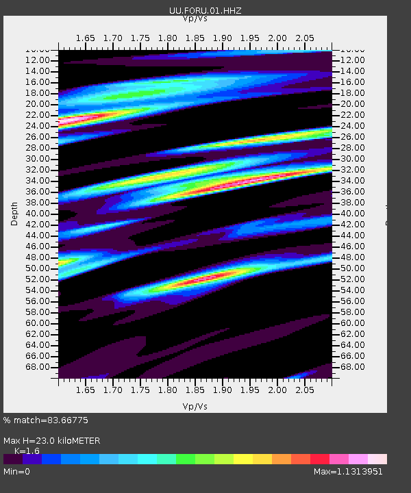
| Estimated Moho Depth: |
23.0 km |
| Estimated Crust Vp/Vs: |
1.60 |
| Assumed Crust Vp: |
6.276 km/s |
| Estimated Crust Vs: |
3.922 km/s |
| Estimated Crust Poisson's Ratio: |
0.18 |
|
| Radial Match: |
83.66775 % |
| Radial Bump: |
400 |
| Transverse Match: |
85.030045 % |
| Transverse Bump: |
400 |
| SOD ConfigId: |
2140511 |
| Insert Time: |
2017-06-16 14:29:34.381 +0000 |
| GWidth: |
2.5 |
| Max Bumps: |
400 |
| Tol: |
0.001 |
|

Signal To Noise
| Channel | StoN | STA | LTA |
| UU:FORU:01:HHZ:20170602T22:33:29.454973Z | 18.85642 | 5.5634366E-8 | 2.9504204E-9 |
| UU:FORU:01:HHN:20170602T22:33:29.454973Z | 10.097197 | 3.6617358E-8 | 3.6264876E-9 |
| UU:FORU:01:HHE:20170602T22:33:29.454973Z | 6.634193 | 4.1165208E-8 | 6.2050067E-9 |
| Arrivals |
| Ps | 2.3 SECOND |
| PpPs | 9.0 SECOND |
| PsPs/PpSs | 11 SECOND |


