You are here: Home > Network List > UU - University of Utah Regional Network Stations List
> Station MTPU Mt. Pierson, UT, USA > Earthquake Result Viewer
MTPU Mt. Pierson, UT, USA - Earthquake Result Viewer
| Earthquake location: |
Near Islands, Aleutian Islands |
| Earthquake latitude/longitude: |
54.0/170.9 |
| Earthquake time(UTC): |
2017/06/02 (153) 22:24:47 GMT |
| Earthquake Depth: |
8.2 km |
| Earthquake Magnitude: |
6.8 Mww |
| Earthquake Catalog/Contributor: |
NEIC PDE/us |
|
| Network: |
UU University of Utah Regional Network |
| Station: |
MTPU Mt. Pierson, UT, USA |
| Lat/Lon: |
38.04 N/112.18 W |
| Elevation: |
3112 m |
|
| Distance: |
53.1 deg |
| Az: |
74.201 deg |
| Baz: |
314.031 deg |
| Ray Param: |
0.06636011 |
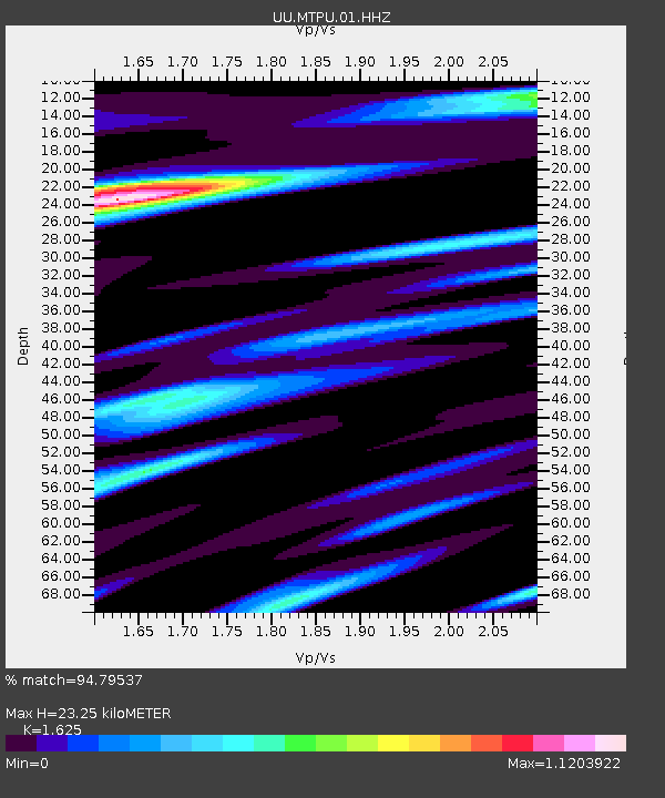
| Estimated Moho Depth: |
23.25 km |
| Estimated Crust Vp/Vs: |
1.62 |
| Assumed Crust Vp: |
6.276 km/s |
| Estimated Crust Vs: |
3.862 km/s |
| Estimated Crust Poisson's Ratio: |
0.20 |
|
| Radial Match: |
94.79537 % |
| Radial Bump: |
400 |
| Transverse Match: |
93.54861 % |
| Transverse Bump: |
400 |
| SOD ConfigId: |
2140511 |
| Insert Time: |
2017-06-16 14:29:51.292 +0000 |
| GWidth: |
2.5 |
| Max Bumps: |
400 |
| Tol: |
0.001 |
|

Signal To Noise
| Channel | StoN | STA | LTA |
| UU:MTPU:01:HHZ:20170602T22:33:34.407976Z | 23.84002 | 7.384969E-8 | 3.0977194E-9 |
| UU:MTPU:01:HHN:20170602T22:33:34.407976Z | 10.324472 | 2.2827072E-8 | 2.2109674E-9 |
| UU:MTPU:01:HHE:20170602T22:33:34.407976Z | 6.0899234 | 2.3590477E-8 | 3.8736903E-9 |
| Arrivals |
| Ps | 2.5 SECOND |
| PpPs | 9.2 SECOND |
| PsPs/PpSs | 12 SECOND |


