You are here: Home > Network List > KN - Kyrgyz Seismic Telemetry Network Stations List
> Station KBK KN.KBK > Earthquake Result Viewer
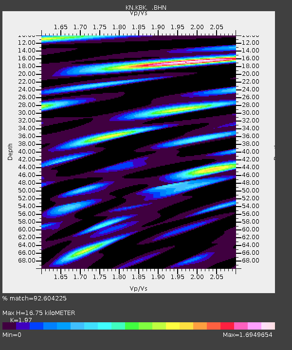
KBK KN.KBK - Earthquake Result Viewer
| Earthquake location: |
South Of Java, Indonesia |
| Earthquake latitude/longitude: |
-10.2/110.6 |
| Earthquake time(UTC): |
2009/09/07 (250) 16:12:22 GMT |
| Earthquake Depth: |
23 km |
| Earthquake Magnitude: |
6.1 MB, 5.9 MS, 6.2 MW, 6.1 MW |
| Earthquake Catalog/Contributor: |
WHDF/NEIC |
|
| Network: |
KN Kyrgyz Seismic Telemetry Network |
| Station: |
KBK KN.KBK |
| Lat/Lon: |
42.66 N/74.95 E |
| Elevation: |
1760 m |
|
| Distance: |
61.9 deg |
| Az: |
330.804 deg |
| Baz: |
139.388 deg |
| Ray Param: |
0.060555864 |
| Estimated Moho Depth: |
16.75 km |
| Estimated Crust Vp/Vs: |
1.97 |
| Assumed Crust Vp: |
6.306 km/s |
| Estimated Crust Vs: |
3.201 km/s |
| Estimated Crust Poisson's Ratio: |
0.33 |
|
| Radial Match: |
92.604225 % |
| Radial Bump: |
400 |
| Transverse Match: |
88.75044 % |
| Transverse Bump: |
400 |
| SOD ConfigId: |
2622 |
| Insert Time: |
2010-03-08 20:19:45.787 +0000 |
| GWidth: |
2.5 |
| Max Bumps: |
400 |
| Tol: |
0.001 |
|

Signal To Noise
| Channel | StoN | STA | LTA |
| KN:KBK: :BHN:20090907T16:22:09.075015Z | 33.751205 | 1.6787769E-6 | 4.973976E-8 |
| KN:KBK: :BHE:20090907T16:22:09.075015Z | 2.9276023 | 4.255149E-7 | 1.4534588E-7 |
| KN:KBK: :BHZ:20090907T16:22:09.075015Z | 3.1152296 | 4.8903587E-7 | 1.569823E-7 |
| Arrivals |
| Ps | 2.7 SECOND |
| PpPs | 7.6 SECOND |
| PsPs/PpSs | 10 SECOND |


