You are here: Home > Network List > KN - Kyrgyz Seismic Telemetry Network Stations List
> Station KBK KN.KBK > Earthquake Result Viewer
KBK KN.KBK - Earthquake Result Viewer
| Earthquake location: |
Mindanao, Philippines |
| Earthquake latitude/longitude: |
6.7/123.4 |
| Earthquake time(UTC): |
2009/10/04 (277) 10:58:00 GMT |
| Earthquake Depth: |
620 km |
| Earthquake Magnitude: |
6.4 MB, 6.6 MW, 6.6 MW |
| Earthquake Catalog/Contributor: |
WHDF/NEIC |
|
| Network: |
KN Kyrgyz Seismic Telemetry Network |
| Station: |
KBK KN.KBK |
| Lat/Lon: |
42.66 N/74.95 E |
| Elevation: |
1760 m |
|
| Distance: |
55.6 deg |
| Az: |
318.024 deg |
| Baz: |
115.782 deg |
| Ray Param: |
0.061987072 |
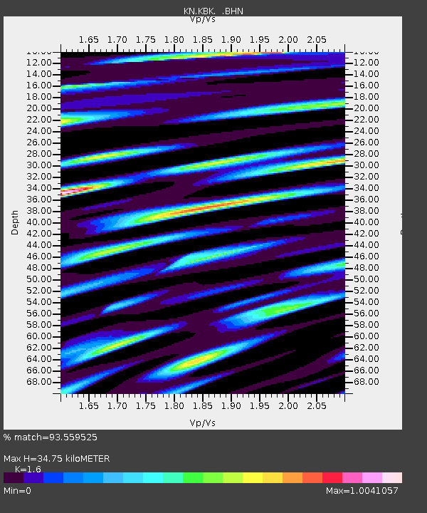
| Estimated Moho Depth: |
34.75 km |
| Estimated Crust Vp/Vs: |
1.60 |
| Assumed Crust Vp: |
6.306 km/s |
| Estimated Crust Vs: |
3.941 km/s |
| Estimated Crust Poisson's Ratio: |
0.18 |
|
| Radial Match: |
93.559525 % |
| Radial Bump: |
400 |
| Transverse Match: |
92.47178 % |
| Transverse Bump: |
400 |
| SOD ConfigId: |
2622 |
| Insert Time: |
2010-03-08 20:19:54.110 +0000 |
| GWidth: |
2.5 |
| Max Bumps: |
400 |
| Tol: |
0.001 |
|
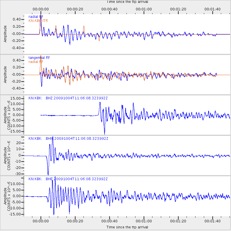
Signal To Noise
| Channel | StoN | STA | LTA |
| KN:KBK: :BHN:20091004T11:06:08.323992Z | 75.26664 | 9.728431E-6 | 1.292529E-7 |
| KN:KBK: :BHE:20091004T11:06:08.323992Z | 10.965782 | 1.2553924E-6 | 1.144827E-7 |
| KN:KBK: :BHZ:20091004T11:06:08.323992Z | 26.987661 | 3.8099236E-6 | 1.4117279E-7 |
| Arrivals |
| Ps | 3.5 SECOND |
| PpPs | 14 SECOND |
| PsPs/PpSs | 17 SECOND |


