You are here: Home > Network List > GT - Global Telemetered Seismograph Network (USAF/USGS) Stations List
> Station LPAZ La Paz , Bolivia > Earthquake Result Viewer
LPAZ La Paz , Bolivia - Earthquake Result Viewer
| Earthquake location: |
Off Coast Of Central Mexico |
| Earthquake latitude/longitude: |
22.4/-108.2 |
| Earthquake time(UTC): |
2020/05/22 (143) 08:46:06 GMT |
| Earthquake Depth: |
10 km |
| Earthquake Magnitude: |
6.1 Mww |
| Earthquake Catalog/Contributor: |
NEIC PDE/us |
|
| Network: |
GT Global Telemetered Seismograph Network (USAF/USGS) |
| Station: |
LPAZ La Paz , Bolivia |
| Lat/Lon: |
16.17 S/68.08 W |
| Elevation: |
4817 m |
|
| Distance: |
54.9 deg |
| Az: |
130.835 deg |
| Baz: |
313.227 deg |
| Ray Param: |
0.06517748 |
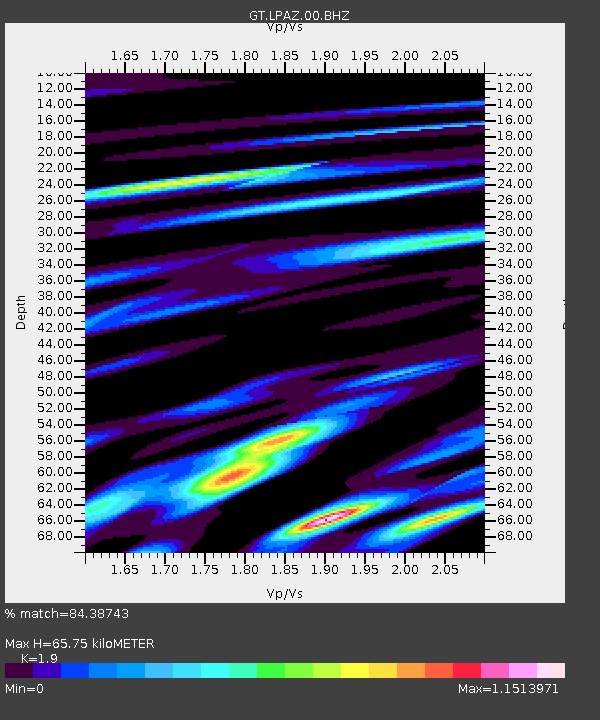
| Estimated Moho Depth: |
65.75 km |
| Estimated Crust Vp/Vs: |
1.90 |
| Assumed Crust Vp: |
6.454 km/s |
| Estimated Crust Vs: |
3.397 km/s |
| Estimated Crust Poisson's Ratio: |
0.31 |
|
| Radial Match: |
84.38743 % |
| Radial Bump: |
400 |
| Transverse Match: |
68.2027 % |
| Transverse Bump: |
400 |
| SOD ConfigId: |
21166931 |
| Insert Time: |
2020-06-05 08:54:44.575 +0000 |
| GWidth: |
2.5 |
| Max Bumps: |
400 |
| Tol: |
0.001 |
|

Signal To Noise
| Channel | StoN | STA | LTA |
| GT:LPAZ:00:BHZ:20200522T08:55:06.474013Z | 4.198092 | 4.0172637E-7 | 9.5692606E-8 |
| GT:LPAZ:00:BHN:20200522T08:55:06.474013Z | 3.5396848 | 2.3751117E-7 | 6.709953E-8 |
| GT:LPAZ:00:BHE:20200522T08:55:06.474013Z | 2.3139985 | 1.7502936E-7 | 7.5639356E-8 |
| Arrivals |
| Ps | 9.6 SECOND |
| PpPs | 28 SECOND |
| PsPs/PpSs | 38 SECOND |


