You are here: Home > Network List > WY - Yellowstone Wyoming Seismic Network Stations List
> Station YMR Madison River, YNP, WY, USA > Earthquake Result Viewer
YMR Madison River, YNP, WY, USA - Earthquake Result Viewer
| Earthquake location: |
Near Islands, Aleutian Islands |
| Earthquake latitude/longitude: |
54.0/170.9 |
| Earthquake time(UTC): |
2017/06/02 (153) 22:24:47 GMT |
| Earthquake Depth: |
8.2 km |
| Earthquake Magnitude: |
6.8 Mww |
| Earthquake Catalog/Contributor: |
NEIC PDE/us |
|
| Network: |
WY Yellowstone Wyoming Seismic Network |
| Station: |
YMR Madison River, YNP, WY, USA |
| Lat/Lon: |
44.67 N/110.96 W |
| Elevation: |
2149 m |
|
| Distance: |
49.3 deg |
| Az: |
67.113 deg |
| Baz: |
310.385 deg |
| Ray Param: |
0.06880328 |
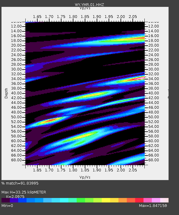
| Estimated Moho Depth: |
33.25 km |
| Estimated Crust Vp/Vs: |
2.10 |
| Assumed Crust Vp: |
6.35 km/s |
| Estimated Crust Vs: |
3.027 km/s |
| Estimated Crust Poisson's Ratio: |
0.35 |
|
| Radial Match: |
91.83995 % |
| Radial Bump: |
400 |
| Transverse Match: |
87.17132 % |
| Transverse Bump: |
400 |
| SOD ConfigId: |
2140511 |
| Insert Time: |
2017-06-16 14:31:01.435 +0000 |
| GWidth: |
2.5 |
| Max Bumps: |
400 |
| Tol: |
0.001 |
|

Signal To Noise
| Channel | StoN | STA | LTA |
| WY:YMR:01:HHZ:20170602T22:33:06.128008Z | 35.245846 | 6.7302565E-8 | 1.9095177E-9 |
| WY:YMR:01:HHN:20170602T22:33:06.128008Z | 6.533075 | 2.6669738E-8 | 4.0822647E-9 |
| WY:YMR:01:HHE:20170602T22:33:06.128008Z | 5.868949 | 2.8022955E-8 | 4.7747823E-9 |
| Arrivals |
| Ps | 6.0 SECOND |
| PpPs | 15 SECOND |
| PsPs/PpSs | 21 SECOND |


