You are here: Home > Network List > N4 - Central and EAstern US Network Stations List
> Station E62A Clayton Lake, ME, USA > Earthquake Result Viewer
E62A Clayton Lake, ME, USA - Earthquake Result Viewer
| Earthquake location: |
Off Coast Of Central Mexico |
| Earthquake latitude/longitude: |
22.4/-108.2 |
| Earthquake time(UTC): |
2020/05/22 (143) 08:46:06 GMT |
| Earthquake Depth: |
10 km |
| Earthquake Magnitude: |
6.1 Mww |
| Earthquake Catalog/Contributor: |
NEIC PDE/us |
|
| Network: |
N4 Central and EAstern US Network |
| Station: |
E62A Clayton Lake, ME, USA |
| Lat/Lon: |
46.62 N/69.52 W |
| Elevation: |
356 m |
|
| Distance: |
39.4 deg |
| Az: |
42.697 deg |
| Baz: |
245.569 deg |
| Ray Param: |
0.07501991 |
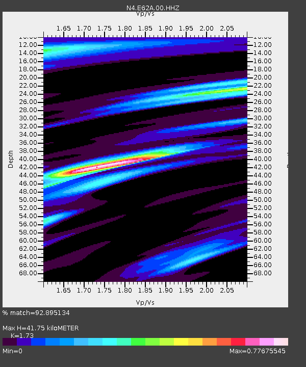
| Estimated Moho Depth: |
41.75 km |
| Estimated Crust Vp/Vs: |
1.73 |
| Assumed Crust Vp: |
6.419 km/s |
| Estimated Crust Vs: |
3.711 km/s |
| Estimated Crust Poisson's Ratio: |
0.25 |
|
| Radial Match: |
92.895134 % |
| Radial Bump: |
315 |
| Transverse Match: |
67.287964 % |
| Transverse Bump: |
400 |
| SOD ConfigId: |
21166931 |
| Insert Time: |
2020-06-05 08:56:25.950 +0000 |
| GWidth: |
2.5 |
| Max Bumps: |
400 |
| Tol: |
0.001 |
|

Signal To Noise
| Channel | StoN | STA | LTA |
| N4:E62A:00:HHZ:20200522T08:53:05.699996Z | 6.816319 | 1.2148538E-6 | 1.7822725E-7 |
| N4:E62A:00:HH1:20200522T08:53:05.699996Z | 3.9149516 | 5.323643E-7 | 1.3598235E-7 |
| N4:E62A:00:HH2:20200522T08:53:05.699996Z | 3.7724676 | 5.925047E-7 | 1.5706024E-7 |
| Arrivals |
| Ps | 5.1 SECOND |
| PpPs | 17 SECOND |
| PsPs/PpSs | 22 SECOND |


