You are here: Home > Network List > TA - USArray Transportable Network (new EarthScope stations) Stations List
> Station E23K Chandalar, AK, USA > Earthquake Result Viewer
E23K Chandalar, AK, USA - Earthquake Result Viewer
| Earthquake location: |
Off Coast Of Central Mexico |
| Earthquake latitude/longitude: |
22.4/-108.2 |
| Earthquake time(UTC): |
2020/05/22 (143) 08:46:06 GMT |
| Earthquake Depth: |
10 km |
| Earthquake Magnitude: |
6.1 Mww |
| Earthquake Catalog/Contributor: |
NEIC PDE/us |
|
| Network: |
TA USArray Transportable Network (new EarthScope stations) |
| Station: |
E23K Chandalar, AK, USA |
| Lat/Lon: |
68.06 N/149.62 W |
| Elevation: |
1084 m |
|
| Distance: |
52.3 deg |
| Az: |
341.667 deg |
| Baz: |
129.239 deg |
| Ray Param: |
0.066859104 |
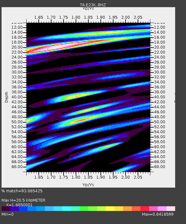
| Estimated Moho Depth: |
20.5 km |
| Estimated Crust Vp/Vs: |
1.69 |
| Assumed Crust Vp: |
6.316 km/s |
| Estimated Crust Vs: |
3.748 km/s |
| Estimated Crust Poisson's Ratio: |
0.23 |
|
| Radial Match: |
93.865425 % |
| Radial Bump: |
400 |
| Transverse Match: |
83.07366 % |
| Transverse Bump: |
400 |
| SOD ConfigId: |
21166931 |
| Insert Time: |
2020-06-05 08:59:46.391 +0000 |
| GWidth: |
2.5 |
| Max Bumps: |
400 |
| Tol: |
0.001 |
|

Signal To Noise
| Channel | StoN | STA | LTA |
| TA:E23K: :BHZ:20200522T08:54:47.22499Z | 2.7081995 | 2.2073083E-7 | 8.1504645E-8 |
| TA:E23K: :BHN:20200522T08:54:47.22499Z | 1.8017797 | 1.1662396E-7 | 6.472709E-8 |
| TA:E23K: :BHE:20200522T08:54:47.22499Z | 1.46325 | 7.882084E-8 | 5.3866966E-8 |
| Arrivals |
| Ps | 2.4 SECOND |
| PpPs | 8.2 SECOND |
| PsPs/PpSs | 11 SECOND |


