You are here: Home > Network List > TA - USArray Transportable Network (new EarthScope stations) Stations List
> Station E27K Coleen River, AK, USA > Earthquake Result Viewer
E27K Coleen River, AK, USA - Earthquake Result Viewer
| Earthquake location: |
Off Coast Of Central Mexico |
| Earthquake latitude/longitude: |
22.4/-108.2 |
| Earthquake time(UTC): |
2020/05/22 (143) 08:46:06 GMT |
| Earthquake Depth: |
10 km |
| Earthquake Magnitude: |
6.1 Mww |
| Earthquake Catalog/Contributor: |
NEIC PDE/us |
|
| Network: |
TA USArray Transportable Network (new EarthScope stations) |
| Station: |
E27K Coleen River, AK, USA |
| Lat/Lon: |
68.19 N/141.60 W |
| Elevation: |
654 m |
|
| Distance: |
50.2 deg |
| Az: |
344.454 deg |
| Baz: |
138.422 deg |
| Ray Param: |
0.068216816 |
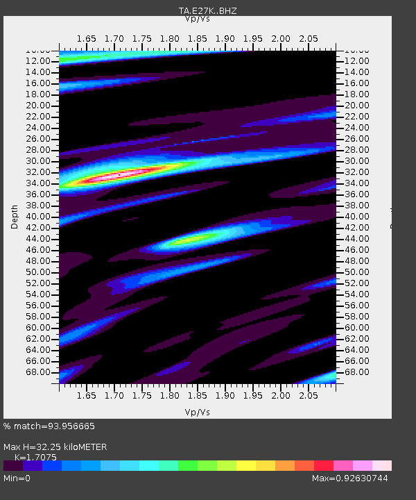
| Estimated Moho Depth: |
32.25 km |
| Estimated Crust Vp/Vs: |
1.71 |
| Assumed Crust Vp: |
6.522 km/s |
| Estimated Crust Vs: |
3.819 km/s |
| Estimated Crust Poisson's Ratio: |
0.24 |
|
| Radial Match: |
93.956665 % |
| Radial Bump: |
380 |
| Transverse Match: |
91.093056 % |
| Transverse Bump: |
351 |
| SOD ConfigId: |
21166931 |
| Insert Time: |
2020-06-05 08:59:49.017 +0000 |
| GWidth: |
2.5 |
| Max Bumps: |
400 |
| Tol: |
0.001 |
|

Signal To Noise
| Channel | StoN | STA | LTA |
| TA:E27K: :BHZ:20200522T08:54:31.650008Z | 3.9097822 | 2.3585433E-7 | 6.032416E-8 |
| TA:E27K: :BHN:20200522T08:54:31.650008Z | 1.4550018 | 1.0519026E-7 | 7.229562E-8 |
| TA:E27K: :BHE:20200522T08:54:31.650008Z | 1.6991998 | 8.7815714E-8 | 5.168063E-8 |
| Arrivals |
| Ps | 3.7 SECOND |
| PpPs | 13 SECOND |
| PsPs/PpSs | 16 SECOND |


