You are here: Home > Network List > TA - USArray Transportable Network (new EarthScope stations) Stations List
> Station F21K Alatna River, AK, USA > Earthquake Result Viewer
F21K Alatna River, AK, USA - Earthquake Result Viewer
| Earthquake location: |
Off Coast Of Central Mexico |
| Earthquake latitude/longitude: |
22.4/-108.2 |
| Earthquake time(UTC): |
2020/05/22 (143) 08:46:06 GMT |
| Earthquake Depth: |
10 km |
| Earthquake Magnitude: |
6.1 Mww |
| Earthquake Catalog/Contributor: |
NEIC PDE/us |
|
| Network: |
TA USArray Transportable Network (new EarthScope stations) |
| Station: |
F21K Alatna River, AK, USA |
| Lat/Lon: |
67.22 N/153.48 W |
| Elevation: |
597 m |
|
| Distance: |
53.0 deg |
| Az: |
339.705 deg |
| Baz: |
124.475 deg |
| Ray Param: |
0.06643118 |
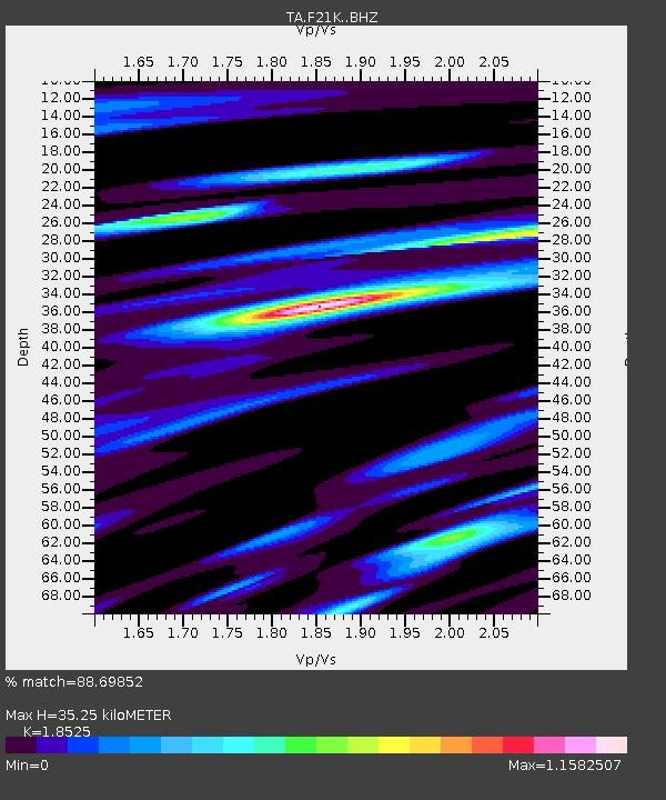
| Estimated Moho Depth: |
35.25 km |
| Estimated Crust Vp/Vs: |
1.85 |
| Assumed Crust Vp: |
6.455 km/s |
| Estimated Crust Vs: |
3.485 km/s |
| Estimated Crust Poisson's Ratio: |
0.29 |
|
| Radial Match: |
88.69852 % |
| Radial Bump: |
400 |
| Transverse Match: |
84.2118 % |
| Transverse Bump: |
400 |
| SOD ConfigId: |
21166931 |
| Insert Time: |
2020-06-05 08:59:59.591 +0000 |
| GWidth: |
2.5 |
| Max Bumps: |
400 |
| Tol: |
0.001 |
|
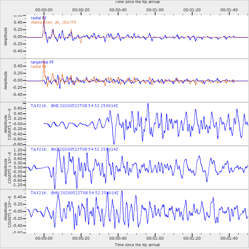
Signal To Noise
| Channel | StoN | STA | LTA |
| TA:F21K: :BHZ:20200522T08:54:52.250014Z | 3.4759328 | 2.6226385E-7 | 7.5451354E-8 |
| TA:F21K: :BHN:20200522T08:54:52.250014Z | 1.6947286 | 1.0186865E-7 | 6.010912E-8 |
| TA:F21K: :BHE:20200522T08:54:52.250014Z | 2.5049582 | 1.5010924E-7 | 5.992485E-8 |
| Arrivals |
| Ps | 4.9 SECOND |
| PpPs | 15 SECOND |
| PsPs/PpSs | 20 SECOND |


