You are here: Home > Network List > TX - Texas Seismological Network Stations List
> Station VHRN Van Horn > Earthquake Result Viewer
VHRN Van Horn - Earthquake Result Viewer
| Earthquake location: |
Near Islands, Aleutian Islands |
| Earthquake latitude/longitude: |
54.0/170.9 |
| Earthquake time(UTC): |
2017/06/02 (153) 22:24:47 GMT |
| Earthquake Depth: |
8.2 km |
| Earthquake Magnitude: |
6.8 Mww |
| Earthquake Catalog/Contributor: |
NEIC PDE/us |
|
| Network: |
TX Texas Seismological Network |
| Station: |
VHRN Van Horn |
| Lat/Lon: |
30.79 N/104.99 W |
| Elevation: |
1342 m |
|
| Distance: |
62.4 deg |
| Az: |
75.017 deg |
| Baz: |
318.53 deg |
| Ray Param: |
0.06025872 |
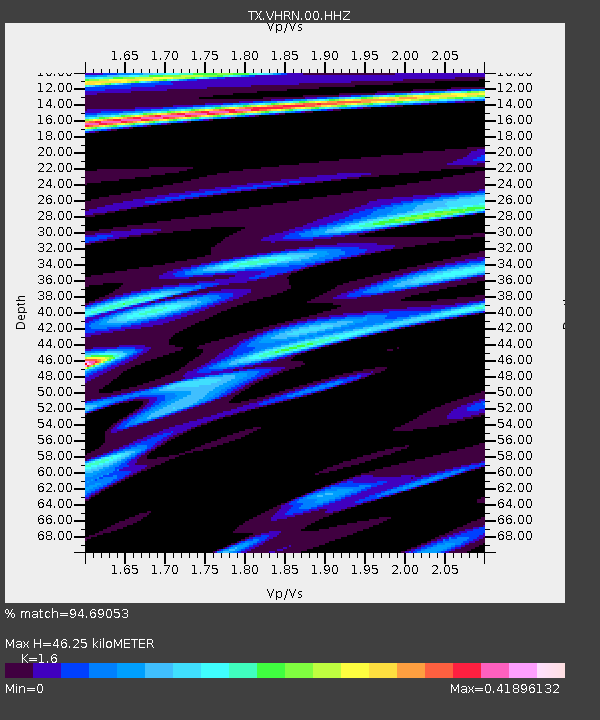
| Estimated Moho Depth: |
46.25 km |
| Estimated Crust Vp/Vs: |
1.60 |
| Assumed Crust Vp: |
6.361 km/s |
| Estimated Crust Vs: |
3.975 km/s |
| Estimated Crust Poisson's Ratio: |
0.18 |
|
| Radial Match: |
94.69053 % |
| Radial Bump: |
348 |
| Transverse Match: |
77.330185 % |
| Transverse Bump: |
400 |
| SOD ConfigId: |
2140511 |
| Insert Time: |
2017-06-16 14:31:58.614 +0000 |
| GWidth: |
2.5 |
| Max Bumps: |
400 |
| Tol: |
0.001 |
|

Signal To Noise
| Channel | StoN | STA | LTA |
| TX:VHRN:00:HHZ:20170602T22:34:39.950029Z | 16.458883 | 1.9810461E-6 | 1.2036334E-7 |
| TX:VHRN:00:HH1:20170602T22:34:39.950029Z | 8.411603 | 7.063037E-7 | 8.3967784E-8 |
| TX:VHRN:00:HH2:20170602T22:34:39.950029Z | 5.632582 | 3.9407985E-7 | 6.996433E-8 |
| Arrivals |
| Ps | 4.6 SECOND |
| PpPs | 18 SECOND |
| PsPs/PpSs | 23 SECOND |


