You are here: Home > Network List > TA - USArray Transportable Network (new EarthScope stations) Stations List
> Station M31M Drury Creek, Yukon, CA > Earthquake Result Viewer
M31M Drury Creek, Yukon, CA - Earthquake Result Viewer
| Earthquake location: |
Off Coast Of Central Mexico |
| Earthquake latitude/longitude: |
22.4/-108.2 |
| Earthquake time(UTC): |
2020/05/22 (143) 08:46:06 GMT |
| Earthquake Depth: |
10 km |
| Earthquake Magnitude: |
6.1 Mww |
| Earthquake Catalog/Contributor: |
NEIC PDE/us |
|
| Network: |
TA USArray Transportable Network (new EarthScope stations) |
| Station: |
M31M Drury Creek, Yukon, CA |
| Lat/Lon: |
62.20 N/134.39 W |
| Elevation: |
639 m |
|
| Distance: |
43.6 deg |
| Az: |
342.525 deg |
| Baz: |
143.645 deg |
| Ray Param: |
0.07243456 |
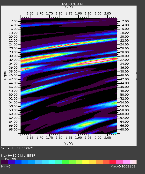
| Estimated Moho Depth: |
32.5 km |
| Estimated Crust Vp/Vs: |
1.99 |
| Assumed Crust Vp: |
6.419 km/s |
| Estimated Crust Vs: |
3.226 km/s |
| Estimated Crust Poisson's Ratio: |
0.33 |
|
| Radial Match: |
82.309265 % |
| Radial Bump: |
369 |
| Transverse Match: |
65.791435 % |
| Transverse Bump: |
400 |
| SOD ConfigId: |
21166931 |
| Insert Time: |
2020-06-05 09:00:57.860 +0000 |
| GWidth: |
2.5 |
| Max Bumps: |
400 |
| Tol: |
0.001 |
|

Signal To Noise
| Channel | StoN | STA | LTA |
| TA:M31M: :BHZ:20200522T08:53:40.324996Z | 2.303837 | 1.682389E-7 | 7.302552E-8 |
| TA:M31M: :BHN:20200522T08:53:40.324996Z | 1.6194009 | 1.0422095E-7 | 6.435772E-8 |
| TA:M31M: :BHE:20200522T08:53:40.324996Z | 0.5281915 | 6.248018E-8 | 1.1829077E-7 |
| Arrivals |
| Ps | 5.3 SECOND |
| PpPs | 14 SECOND |
| PsPs/PpSs | 20 SECOND |


