You are here: Home > Network List > TX - Texas Seismological Network Stations List
> Station WTFS Witchita Falls > Earthquake Result Viewer
WTFS Witchita Falls - Earthquake Result Viewer
| Earthquake location: |
Near Islands, Aleutian Islands |
| Earthquake latitude/longitude: |
54.0/170.9 |
| Earthquake time(UTC): |
2017/06/02 (153) 22:24:47 GMT |
| Earthquake Depth: |
8.2 km |
| Earthquake Magnitude: |
6.8 Mww |
| Earthquake Catalog/Contributor: |
NEIC PDE/us |
|
| Network: |
TX Texas Seismological Network |
| Station: |
WTFS Witchita Falls |
| Lat/Lon: |
33.77 N/98.46 W |
| Elevation: |
277 m |
|
| Distance: |
63.8 deg |
| Az: |
68.167 deg |
| Baz: |
318.898 deg |
| Ray Param: |
0.05933732 |
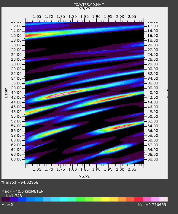
| Estimated Moho Depth: |
40.5 km |
| Estimated Crust Vp/Vs: |
1.75 |
| Assumed Crust Vp: |
6.426 km/s |
| Estimated Crust Vs: |
3.683 km/s |
| Estimated Crust Poisson's Ratio: |
0.26 |
|
| Radial Match: |
94.62356 % |
| Radial Bump: |
400 |
| Transverse Match: |
89.30114 % |
| Transverse Bump: |
400 |
| SOD ConfigId: |
2140511 |
| Insert Time: |
2017-06-16 14:32:07.331 +0000 |
| GWidth: |
2.5 |
| Max Bumps: |
400 |
| Tol: |
0.001 |
|
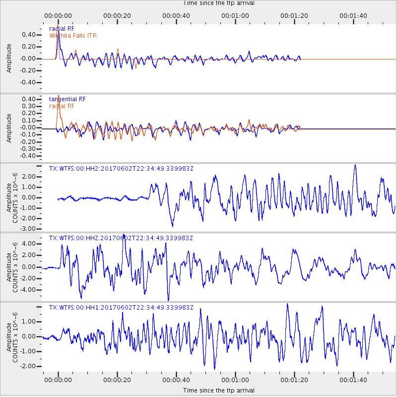
Signal To Noise
| Channel | StoN | STA | LTA |
| TX:WTFS:00:HHZ:20170602T22:34:49.339983Z | 27.740526 | 2.0052446E-6 | 7.228575E-8 |
| TX:WTFS:00:HH1:20170602T22:34:49.339983Z | 4.7518215 | 3.2096392E-7 | 6.754545E-8 |
| TX:WTFS:00:HH2:20170602T22:34:49.339983Z | 7.3821507 | 7.472452E-7 | 1.0122324E-7 |
| Arrivals |
| Ps | 4.9 SECOND |
| PpPs | 17 SECOND |
| PsPs/PpSs | 21 SECOND |


