You are here: Home > Network List > WI - West Indies IPGP Network Stations List
> Station BIM Morne Bigot, Anses d'Arlets, Martinique > Earthquake Result Viewer
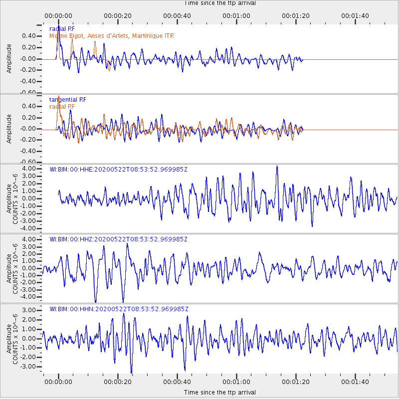
BIM Morne Bigot, Anses d'Arlets, Martinique - Earthquake Result Viewer

| Earthquake location: |
Off Coast Of Central Mexico |
| Earthquake latitude/longitude: |
22.4/-108.2 |
| Earthquake time(UTC): |
2020/05/22 (143) 08:46:06 GMT |
| Earthquake Depth: |
10 km |
| Earthquake Magnitude: |
6.1 Mww |
| Earthquake Catalog/Contributor: |
NEIC PDE/us |
|
| Network: |
WI West Indies IPGP Network |
| Station: |
BIM Morne Bigot, Anses d'Arlets, Martinique |
| Lat/Lon: |
14.52 N/61.07 W |
| Elevation: |
391 m |
|
| Distance: |
45.2 deg |
| Az: |
91.558 deg |
| Baz: |
287.216 deg |
| Ray Param: |
0.07143682 |
| Estimated Moho Depth: |
33.0 km |
| Estimated Crust Vp/Vs: |
1.92 |
| Assumed Crust Vp: |
5.88 km/s |
| Estimated Crust Vs: |
3.063 km/s |
| Estimated Crust Poisson's Ratio: |
0.31 |
|
| Radial Match: |
85.137375 % |
| Radial Bump: |
400 |
| Transverse Match: |
76.54667 % |
| Transverse Bump: |
400 |
| SOD ConfigId: |
21166931 |
| Insert Time: |
2020-06-05 09:01:51.509 +0000 |
| GWidth: |
2.5 |
| Max Bumps: |
400 |
| Tol: |
0.001 |
|
Signal To Noise
| Channel | StoN | STA | LTA |
| WI:BIM:00:HHZ:20200522T08:53:52.969985Z | 2.8742118 | 1.1521419E-6 | 4.0085487E-7 |
| WI:BIM:00:HHN:20200522T08:53:52.969985Z | 0.74680156 | 3.5875348E-7 | 4.8038663E-7 |
| WI:BIM:00:HHE:20200522T08:53:52.969985Z | 1.9276541 | 9.667498E-7 | 5.015162E-7 |
| Arrivals |
| Ps | 5.4 SECOND |
| PpPs | 16 SECOND |
| PsPs/PpSs | 21 SECOND |


