You are here: Home > Network List > TX - Texas Seismological Network Stations List
> Station DRIO Del Rio > Earthquake Result Viewer
DRIO Del Rio - Earthquake Result Viewer
| Earthquake location: |
Near Islands, Aleutian Islands |
| Earthquake latitude/longitude: |
54.0/170.9 |
| Earthquake time(UTC): |
2017/06/02 (153) 22:24:47 GMT |
| Earthquake Depth: |
8.2 km |
| Earthquake Magnitude: |
6.8 Mww |
| Earthquake Catalog/Contributor: |
NEIC PDE/us |
|
| Network: |
TX Texas Seismological Network |
| Station: |
DRIO Del Rio |
| Lat/Lon: |
29.42 N/100.62 W |
| Elevation: |
354 m |
|
| Distance: |
65.9 deg |
| Az: |
72.825 deg |
| Baz: |
319.754 deg |
| Ray Param: |
0.05797372 |
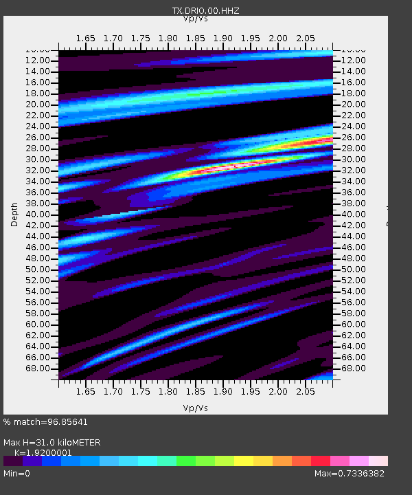
| Estimated Moho Depth: |
31.0 km |
| Estimated Crust Vp/Vs: |
1.92 |
| Assumed Crust Vp: |
6.12 km/s |
| Estimated Crust Vs: |
3.187 km/s |
| Estimated Crust Poisson's Ratio: |
0.31 |
|
| Radial Match: |
96.85641 % |
| Radial Bump: |
315 |
| Transverse Match: |
86.918976 % |
| Transverse Bump: |
400 |
| SOD ConfigId: |
2140511 |
| Insert Time: |
2017-06-16 14:32:32.169 +0000 |
| GWidth: |
2.5 |
| Max Bumps: |
400 |
| Tol: |
0.001 |
|

Signal To Noise
| Channel | StoN | STA | LTA |
| TX:DRIO:00:HHZ:20170602T22:35:02.904985Z | 24.411669 | 1.5843148E-6 | 6.489989E-8 |
| TX:DRIO:00:HH1:20170602T22:35:02.904985Z | 11.298182 | 6.384201E-7 | 5.6506444E-8 |
| TX:DRIO:00:HH2:20170602T22:35:02.904985Z | 9.014315 | 5.5238905E-7 | 6.1279096E-8 |
| Arrivals |
| Ps | 4.8 SECOND |
| PpPs | 14 SECOND |
| PsPs/PpSs | 19 SECOND |


