You are here: Home > Network List > TX - Texas Seismological Network Stations List
> Station FW15 Z > Earthquake Result Viewer
FW15 Z - Earthquake Result Viewer

| Earthquake location: |
Near Islands, Aleutian Islands |
| Earthquake latitude/longitude: |
54.0/170.9 |
| Earthquake time(UTC): |
2017/06/02 (153) 22:24:47 GMT |
| Earthquake Depth: |
8.2 km |
| Earthquake Magnitude: |
6.8 Mww |
| Earthquake Catalog/Contributor: |
NEIC PDE/us |
|
| Network: |
TX Texas Seismological Network |
| Station: |
FW15 Z |
| Lat/Lon: |
32.70 N/97.37 W |
| Elevation: |
192 m |
|
| Distance: |
65.2 deg |
| Az: |
68.164 deg |
| Baz: |
319.494 deg |
| Ray Param: |
0.058423635 |
| Estimated Moho Depth: |
61.25 km |
| Estimated Crust Vp/Vs: |
2.01 |
| Assumed Crust Vp: |
6.38 km/s |
| Estimated Crust Vs: |
3.178 km/s |
| Estimated Crust Poisson's Ratio: |
0.33 |
|
| Radial Match: |
86.05628 % |
| Radial Bump: |
400 |
| Transverse Match: |
79.999725 % |
| Transverse Bump: |
400 |
| SOD ConfigId: |
2140511 |
| Insert Time: |
2017-06-16 14:32:33.267 +0000 |
| GWidth: |
2.5 |
| Max Bumps: |
400 |
| Tol: |
0.001 |
|
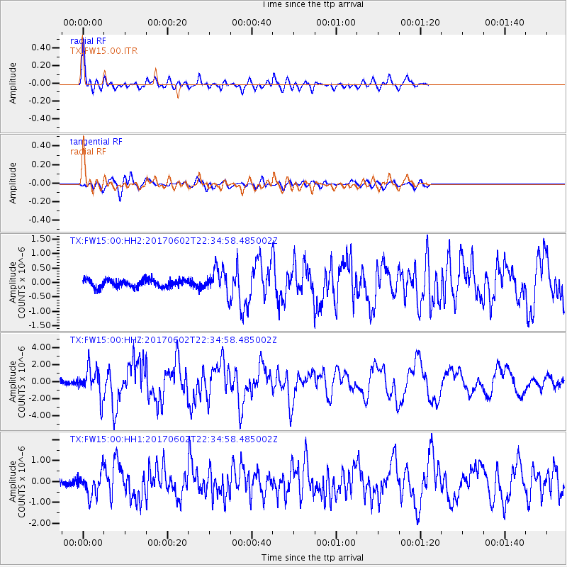
Signal To Noise
| Channel | StoN | STA | LTA |
| TX:FW15:00:HHZ:20170602T22:34:58.485002Z | 9.6188965 | 1.7796657E-6 | 1.8501765E-7 |
| TX:FW15:00:HH1:20170602T22:34:58.485002Z | 5.599565 | 5.7467E-7 | 1.02627624E-7 |
| TX:FW15:00:HH2:20170602T22:34:58.485002Z | 3.2349513 | 4.321801E-7 | 1.335971E-7 |
| Arrivals |
| Ps | 10 SECOND |
| PpPs | 28 SECOND |
| PsPs/PpSs | 38 SECOND |


