You are here: Home > Network List > GS - US Geological Survey Networks Stations List
> Station KAN08 Pence Farm, Harper, KS, USA > Earthquake Result Viewer
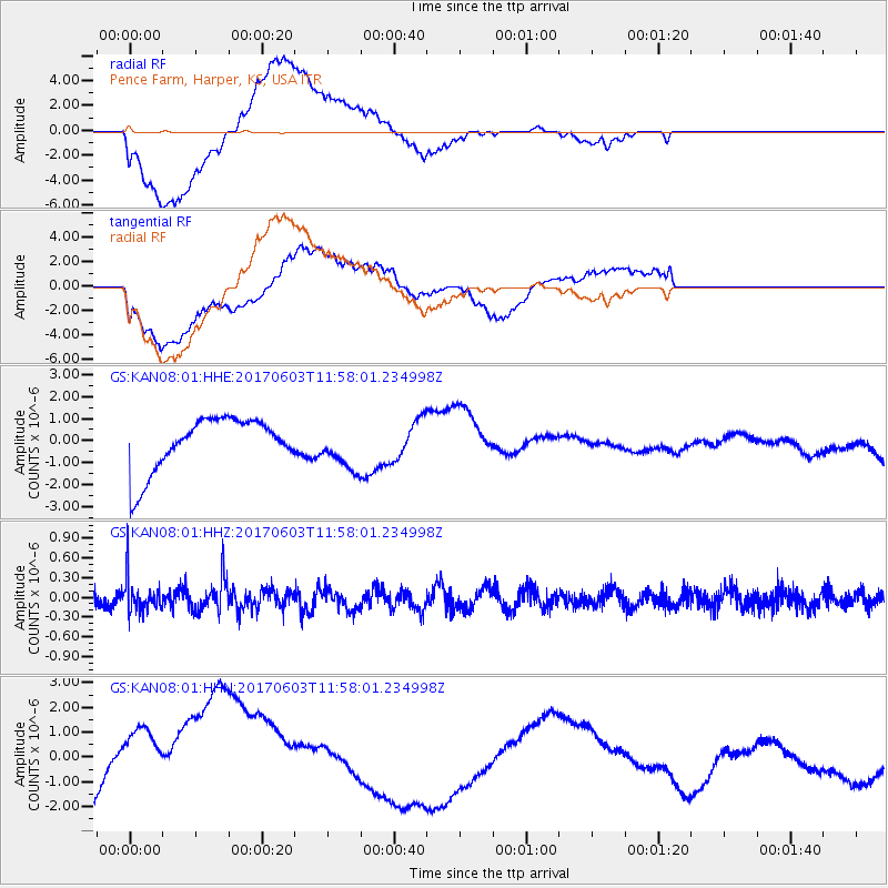
KAN08 Pence Farm, Harper, KS, USA - Earthquake Result Viewer
*The percent match for this event was below the threshold and hence no stack was calculated.
| Earthquake location: |
Kuril Islands |
| Earthquake latitude/longitude: |
50.9/157.3 |
| Earthquake time(UTC): |
2017/06/03 (154) 11:47:23 GMT |
| Earthquake Depth: |
44 km |
| Earthquake Magnitude: |
5.1 Mww |
| Earthquake Catalog/Contributor: |
NEIC PDE/us |
|
| Network: |
GS US Geological Survey Networks |
| Station: |
KAN08 Pence Farm, Harper, KS, USA |
| Lat/Lon: |
37.23 N/97.97 W |
| Elevation: |
375 m |
|
| Distance: |
70.3 deg |
| Az: |
55.076 deg |
| Baz: |
319.391 deg |
| Ray Param: |
$rayparam |
*The percent match for this event was below the threshold and hence was not used in the summary stack. |
|
| Radial Match: |
56.072495 % |
| Radial Bump: |
400 |
| Transverse Match: |
51.778805 % |
| Transverse Bump: |
400 |
| SOD ConfigId: |
2140511 |
| Insert Time: |
2017-06-17 03:46:00.097 +0000 |
| GWidth: |
2.5 |
| Max Bumps: |
400 |
| Tol: |
0.001 |
|
Signal To Noise
| Channel | StoN | STA | LTA |
| GS:KAN08:01:HHZ:20170603T11:58:01.234998Z | 2.3617957 | 2.5504906E-7 | 1.0798947E-7 |
| GS:KAN08:01:HHN:20170603T11:58:01.234998Z | 2.401544 | 2.4046699E-6 | 1.0013015E-6 |
| GS:KAN08:01:HHE:20170603T11:58:01.234998Z | 0.81442434 | 9.936093E-7 | 1.2200144E-6 |
| Arrivals |
| Ps | |
| PpPs | |
| PsPs/PpSs | |


