You are here: Home > Network List > TA - USArray Transportable Network (new EarthScope stations) Stations List
> Station C23K Itkillik River, AK, USA > Earthquake Result Viewer
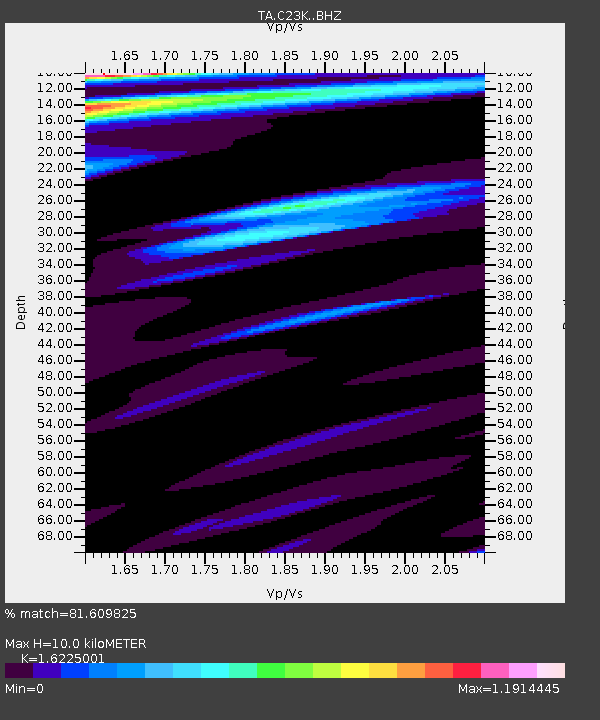
C23K Itkillik River, AK, USA - Earthquake Result Viewer
| Earthquake location: |
Vanuatu Islands |
| Earthquake latitude/longitude: |
-17.2/167.9 |
| Earthquake time(UTC): |
2020/05/27 (148) 07:09:10 GMT |
| Earthquake Depth: |
10 km |
| Earthquake Magnitude: |
6.1 mww |
| Earthquake Catalog/Contributor: |
NEIC PDE/us |
|
| Network: |
TA USArray Transportable Network (new EarthScope stations) |
| Station: |
C23K Itkillik River, AK, USA |
| Lat/Lon: |
69.84 N/150.61 W |
| Elevation: |
179 m |
|
| Distance: |
91.5 deg |
| Az: |
13.294 deg |
| Baz: |
219.347 deg |
| Ray Param: |
0.04159504 |
| Estimated Moho Depth: |
10.0 km |
| Estimated Crust Vp/Vs: |
1.62 |
| Assumed Crust Vp: |
6.221 km/s |
| Estimated Crust Vs: |
3.834 km/s |
| Estimated Crust Poisson's Ratio: |
0.19 |
|
| Radial Match: |
81.609825 % |
| Radial Bump: |
284 |
| Transverse Match: |
60.28908 % |
| Transverse Bump: |
400 |
| SOD ConfigId: |
21166931 |
| Insert Time: |
2020-06-10 07:19:10.868 +0000 |
| GWidth: |
2.5 |
| Max Bumps: |
400 |
| Tol: |
0.001 |
|

Signal To Noise
| Channel | StoN | STA | LTA |
| TA:C23K: :BHZ:20200527T07:21:45.824977Z | 1.9408265 | 2.1090159E-7 | 1.0866586E-7 |
| TA:C23K: :BHN:20200527T07:21:45.824977Z | 2.05103 | 1.8926781E-7 | 9.22794E-8 |
| TA:C23K: :BHE:20200527T07:21:45.824977Z | 1.1201012 | 1.4402116E-7 | 1.285787E-7 |
| Arrivals |
| Ps | 1.0 SECOND |
| PpPs | 4.1 SECOND |
| PsPs/PpSs | 5.1 SECOND |


