You are here: Home > Network List > TA - USArray Transportable Network (new EarthScope stations) Stations List
> Station M15K Kasigluk River, AK, USA > Earthquake Result Viewer
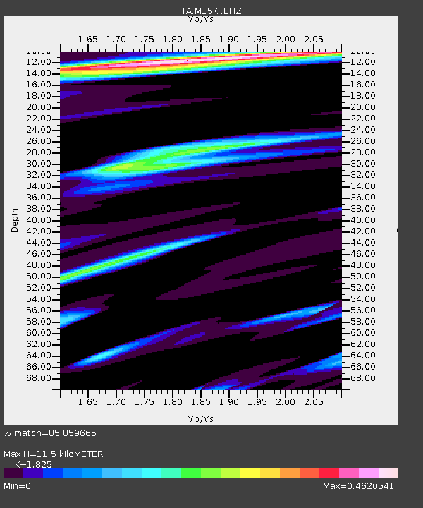
M15K Kasigluk River, AK, USA - Earthquake Result Viewer
| Earthquake location: |
Vanuatu Islands |
| Earthquake latitude/longitude: |
-17.2/167.9 |
| Earthquake time(UTC): |
2020/05/27 (148) 07:09:10 GMT |
| Earthquake Depth: |
10 km |
| Earthquake Magnitude: |
6.1 mww |
| Earthquake Catalog/Contributor: |
NEIC PDE/us |
|
| Network: |
TA USArray Transportable Network (new EarthScope stations) |
| Station: |
M15K Kasigluk River, AK, USA |
| Lat/Lon: |
60.69 N/160.69 W |
| Elevation: |
210 m |
|
| Distance: |
81.6 deg |
| Az: |
15.037 deg |
| Baz: |
210.278 deg |
| Ray Param: |
0.047476206 |
| Estimated Moho Depth: |
11.5 km |
| Estimated Crust Vp/Vs: |
1.83 |
| Assumed Crust Vp: |
6.182 km/s |
| Estimated Crust Vs: |
3.388 km/s |
| Estimated Crust Poisson's Ratio: |
0.29 |
|
| Radial Match: |
85.859665 % |
| Radial Bump: |
400 |
| Transverse Match: |
53.92042 % |
| Transverse Bump: |
400 |
| SOD ConfigId: |
21166931 |
| Insert Time: |
2020-06-10 07:19:54.139 +0000 |
| GWidth: |
2.5 |
| Max Bumps: |
400 |
| Tol: |
0.001 |
|

Signal To Noise
| Channel | StoN | STA | LTA |
| TA:M15K: :BHZ:20200527T07:20:57.250026Z | 2.5485477 | 1.6404668E-7 | 6.436869E-8 |
| TA:M15K: :BHN:20200527T07:20:57.250026Z | 1.055297 | 1.6328663E-7 | 1.5473051E-7 |
| TA:M15K: :BHE:20200527T07:20:57.250026Z | 0.64784026 | 5.8130553E-8 | 8.972977E-8 |
| Arrivals |
| Ps | 1.6 SECOND |
| PpPs | 5.1 SECOND |
| PsPs/PpSs | 6.7 SECOND |


