You are here: Home > Network List > TA - USArray Transportable Network (new EarthScope stations) Stations List
> Station M22K Willow, AK, USA > Earthquake Result Viewer
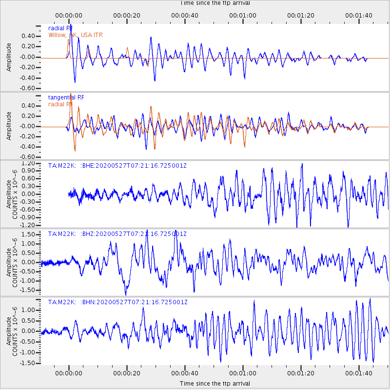
M22K Willow, AK, USA - Earthquake Result Viewer

| Earthquake location: |
Vanuatu Islands |
| Earthquake latitude/longitude: |
-17.2/167.9 |
| Earthquake time(UTC): |
2020/05/27 (148) 07:09:10 GMT |
| Earthquake Depth: |
10 km |
| Earthquake Magnitude: |
6.1 mww |
| Earthquake Catalog/Contributor: |
NEIC PDE/us |
|
| Network: |
TA USArray Transportable Network (new EarthScope stations) |
| Station: |
M22K Willow, AK, USA |
| Lat/Lon: |
61.75 N/150.12 W |
| Elevation: |
57 m |
|
| Distance: |
85.4 deg |
| Az: |
18.63 deg |
| Baz: |
219.939 deg |
| Ray Param: |
0.044785827 |
| Estimated Moho Depth: |
54.0 km |
| Estimated Crust Vp/Vs: |
1.76 |
| Assumed Crust Vp: |
6.302 km/s |
| Estimated Crust Vs: |
3.586 km/s |
| Estimated Crust Poisson's Ratio: |
0.26 |
|
| Radial Match: |
87.20708 % |
| Radial Bump: |
400 |
| Transverse Match: |
80.93061 % |
| Transverse Bump: |
400 |
| SOD ConfigId: |
21166931 |
| Insert Time: |
2020-06-10 07:19:57.578 +0000 |
| GWidth: |
2.5 |
| Max Bumps: |
400 |
| Tol: |
0.001 |
|
Signal To Noise
| Channel | StoN | STA | LTA |
| TA:M22K: :BHZ:20200527T07:21:16.725001Z | 2.983361 | 2.783237E-7 | 9.3291995E-8 |
| TA:M22K: :BHN:20200527T07:21:16.725001Z | 1.5107889 | 2.7485328E-7 | 1.8192699E-7 |
| TA:M22K: :BHE:20200527T07:21:16.725001Z | 1.3943473 | 1.7524604E-7 | 1.256832E-7 |
| Arrivals |
| Ps | 6.6 SECOND |
| PpPs | 23 SECOND |
| PsPs/PpSs | 30 SECOND |


