You are here: Home > Network List > IW - Intermountain West Stations List
> Station PLID Pearl Lake, Idaho, USA > Earthquake Result Viewer
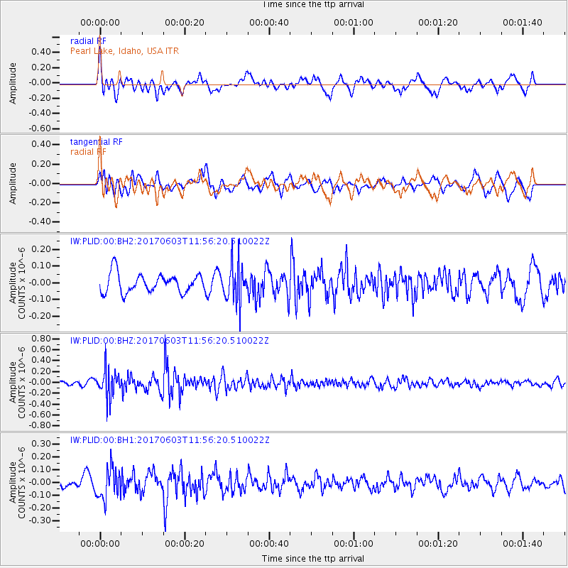
PLID Pearl Lake, Idaho, USA - Earthquake Result Viewer
*The percent match for this event was below the threshold and hence no stack was calculated.
| Earthquake location: |
Kuril Islands |
| Earthquake latitude/longitude: |
50.9/157.3 |
| Earthquake time(UTC): |
2017/06/03 (154) 11:47:23 GMT |
| Earthquake Depth: |
44 km |
| Earthquake Magnitude: |
5.1 Mww |
| Earthquake Catalog/Contributor: |
NEIC PDE/us |
|
| Network: |
IW Intermountain West |
| Station: |
PLID Pearl Lake, Idaho, USA |
| Lat/Lon: |
45.09 N/116.00 W |
| Elevation: |
2164 m |
|
| Distance: |
55.1 deg |
| Az: |
59.541 deg |
| Baz: |
309.553 deg |
| Ray Param: |
$rayparam |
*The percent match for this event was below the threshold and hence was not used in the summary stack. |
|
| Radial Match: |
60.673363 % |
| Radial Bump: |
400 |
| Transverse Match: |
54.98939 % |
| Transverse Bump: |
400 |
| SOD ConfigId: |
2140511 |
| Insert Time: |
2017-06-17 03:47:26.909 +0000 |
| GWidth: |
2.5 |
| Max Bumps: |
400 |
| Tol: |
0.001 |
|
Signal To Noise
| Channel | StoN | STA | LTA |
| IW:PLID:00:BHZ:20170603T11:56:20.510022Z | 6.09693 | 2.5494586E-7 | 4.1815447E-8 |
| IW:PLID:00:BH1:20170603T11:56:20.510022Z | 4.0230193 | 1.2043776E-7 | 2.9937155E-8 |
| IW:PLID:00:BH2:20170603T11:56:20.510022Z | 1.9523107 | 1.1012784E-7 | 5.6408975E-8 |
| Arrivals |
| Ps | |
| PpPs | |
| PsPs/PpSs | |


