You are here: Home > Network List > TA - USArray Transportable Network (new EarthScope stations) Stations List
> Station POKR Poker Plat Research Range, AK, USA > Earthquake Result Viewer
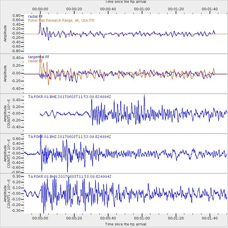
POKR Poker Plat Research Range, AK, USA - Earthquake Result Viewer
*The percent match for this event was below the threshold and hence no stack was calculated.
| Earthquake location: |
Kuril Islands |
| Earthquake latitude/longitude: |
50.9/157.3 |
| Earthquake time(UTC): |
2017/06/03 (154) 11:47:23 GMT |
| Earthquake Depth: |
44 km |
| Earthquake Magnitude: |
5.1 Mww |
| Earthquake Catalog/Contributor: |
NEIC PDE/us |
|
| Network: |
TA USArray Transportable Network (new EarthScope stations) |
| Station: |
POKR Poker Plat Research Range, AK, USA |
| Lat/Lon: |
65.12 N/147.43 W |
| Elevation: |
501 m |
|
| Distance: |
31.4 deg |
| Az: |
41.89 deg |
| Baz: |
270.042 deg |
| Ray Param: |
$rayparam |
*The percent match for this event was below the threshold and hence was not used in the summary stack. |
|
| Radial Match: |
73.124275 % |
| Radial Bump: |
400 |
| Transverse Match: |
50.082664 % |
| Transverse Bump: |
400 |
| SOD ConfigId: |
2140511 |
| Insert Time: |
2017-06-17 03:49:29.927 +0000 |
| GWidth: |
2.5 |
| Max Bumps: |
400 |
| Tol: |
0.001 |
|
Signal To Noise
| Channel | StoN | STA | LTA |
| TA:POKR:01:BHZ:20170603T11:53:09.824994Z | 8.017715 | 2.861554E-7 | 3.569039E-8 |
| TA:POKR:01:BHN:20170603T11:53:09.824994Z | 3.1729376 | 1.3568695E-7 | 4.2763823E-8 |
| TA:POKR:01:BHE:20170603T11:53:09.824994Z | 4.4447412 | 1.741164E-7 | 3.917357E-8 |
| Arrivals |
| Ps | |
| PpPs | |
| PsPs/PpSs | |


