You are here: Home > Network List > TA - USArray Transportable Network (new EarthScope stations) Stations List
> Station C16K Lisburne Hills, AK, USA > Earthquake Result Viewer
C16K Lisburne Hills, AK, USA - Earthquake Result Viewer
| Earthquake location: |
Vanuatu Islands |
| Earthquake latitude/longitude: |
-18.7/168.1 |
| Earthquake time(UTC): |
2020/05/27 (148) 07:09:18 GMT |
| Earthquake Depth: |
10 km |
| Earthquake Magnitude: |
6.1 Mww |
| Earthquake Catalog/Contributor: |
NEIC PDE/us |
|
| Network: |
TA USArray Transportable Network (new EarthScope stations) |
| Station: |
C16K Lisburne Hills, AK, USA |
| Lat/Lon: |
68.27 N/165.34 W |
| Elevation: |
102 m |
|
| Distance: |
88.9 deg |
| Az: |
9.582 deg |
| Baz: |
205.07 deg |
| Ray Param: |
0.042251304 |
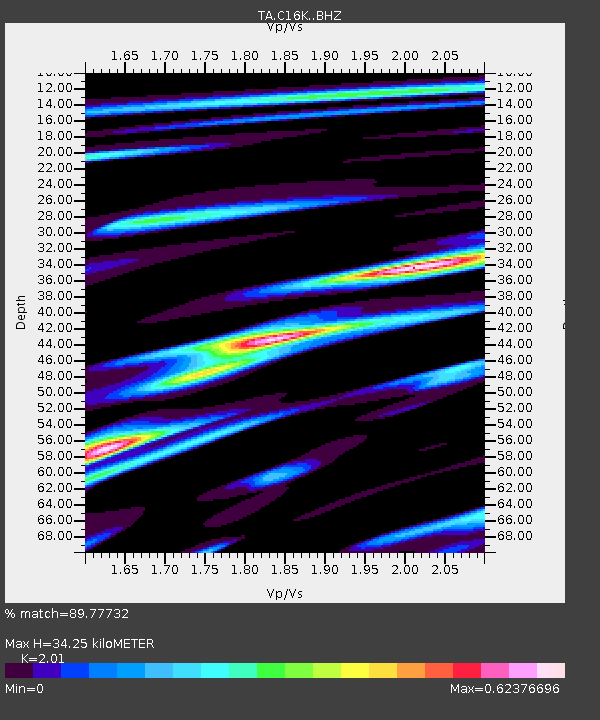
| Estimated Moho Depth: |
34.25 km |
| Estimated Crust Vp/Vs: |
2.01 |
| Assumed Crust Vp: |
5.906 km/s |
| Estimated Crust Vs: |
2.939 km/s |
| Estimated Crust Poisson's Ratio: |
0.34 |
|
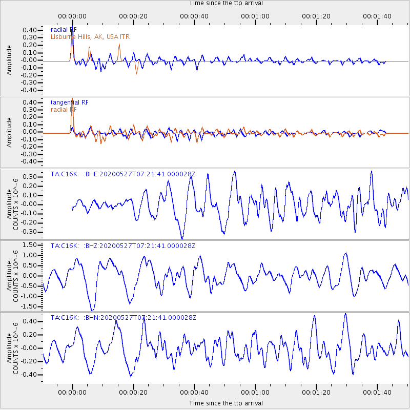
| Radial Match: |
89.77732 % |
| Radial Bump: |
400 |
| Transverse Match: |
80.7821 % |
| Transverse Bump: |
400 |
| SOD ConfigId: |
21166931 |
| Insert Time: |
2020-06-10 07:36:16.787 +0000 |
| GWidth: |
2.5 |
| Max Bumps: |
400 |
| Tol: |
0.001 |
|
Signal To Noise
| Channel | StoN | STA | LTA |
| TA:C16K: :BHZ:20200527T07:21:41.000028Z | 2.8070898 | 5.452548E-7 | 1.9424203E-7 |
| TA:C16K: :BHN:20200527T07:21:41.000028Z | 2.57973 | 1.853582E-7 | 7.185178E-8 |
| TA:C16K: :BHE:20200527T07:21:41.000028Z | 2.3278544 | 1.4414591E-7 | 6.1922215E-8 |
| Arrivals |
| Ps | 6.0 SECOND |
| PpPs | 17 SECOND |
| PsPs/PpSs | 23 SECOND |


