You are here: Home > Network List > TA - USArray Transportable Network (new EarthScope stations) Stations List
> Station C21K Knifeblade Ridge, AK, USA > Earthquake Result Viewer
C21K Knifeblade Ridge, AK, USA - Earthquake Result Viewer
| Earthquake location: |
Vanuatu Islands |
| Earthquake latitude/longitude: |
-18.7/168.1 |
| Earthquake time(UTC): |
2020/05/27 (148) 07:09:18 GMT |
| Earthquake Depth: |
10 km |
| Earthquake Magnitude: |
6.1 Mww |
| Earthquake Catalog/Contributor: |
NEIC PDE/us |
|
| Network: |
TA USArray Transportable Network (new EarthScope stations) |
| Station: |
C21K Knifeblade Ridge, AK, USA |
| Lat/Lon: |
69.16 N/154.78 W |
| Elevation: |
409 m |
|
| Distance: |
91.6 deg |
| Az: |
12.477 deg |
| Baz: |
214.893 deg |
| Ray Param: |
0.041589055 |
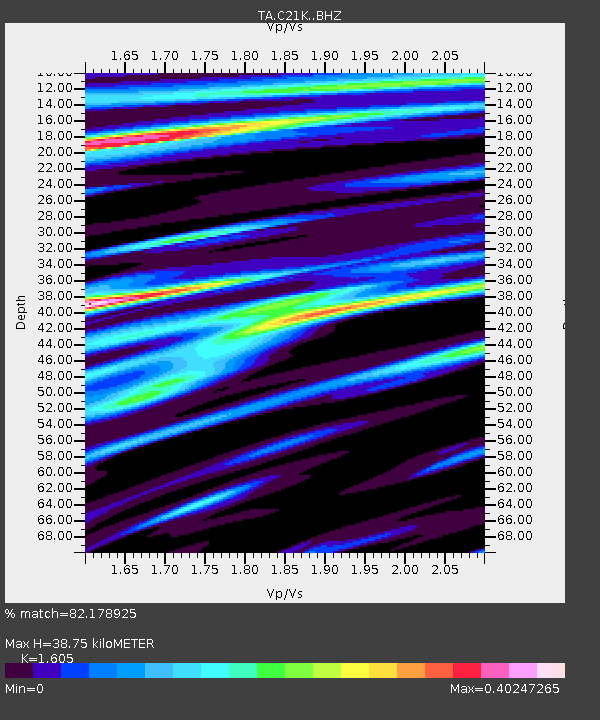
| Estimated Moho Depth: |
38.75 km |
| Estimated Crust Vp/Vs: |
1.61 |
| Assumed Crust Vp: |
6.221 km/s |
| Estimated Crust Vs: |
3.876 km/s |
| Estimated Crust Poisson's Ratio: |
0.18 |
|
| Radial Match: |
82.178925 % |
| Radial Bump: |
400 |
| Transverse Match: |
68.64559 % |
| Transverse Bump: |
400 |
| SOD ConfigId: |
21166931 |
| Insert Time: |
2020-06-10 07:36:22.668 +0000 |
| GWidth: |
2.5 |
| Max Bumps: |
400 |
| Tol: |
0.001 |
|

Signal To Noise
| Channel | StoN | STA | LTA |
| TA:C21K: :BHZ:20200527T07:21:53.449979Z | 3.0297937 | 6.121813E-7 | 2.0205378E-7 |
| TA:C21K: :BHN:20200527T07:21:53.449979Z | 1.7251616 | 1.1966456E-7 | 6.936426E-8 |
| TA:C21K: :BHE:20200527T07:21:53.449979Z | 1.0503279 | 9.435749E-8 | 8.983621E-8 |
| Arrivals |
| Ps | 3.8 SECOND |
| PpPs | 16 SECOND |
| PsPs/PpSs | 20 SECOND |


