You are here: Home > Network List > US - United States National Seismic Network Stations List
> Station CBKS Cedar Bluff, Kansas, USA > Earthquake Result Viewer
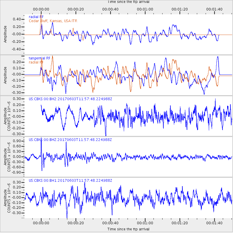
CBKS Cedar Bluff, Kansas, USA - Earthquake Result Viewer
*The percent match for this event was below the threshold and hence no stack was calculated.
| Earthquake location: |
Kuril Islands |
| Earthquake latitude/longitude: |
50.9/157.3 |
| Earthquake time(UTC): |
2017/06/03 (154) 11:47:23 GMT |
| Earthquake Depth: |
44 km |
| Earthquake Magnitude: |
5.1 Mww |
| Earthquake Catalog/Contributor: |
NEIC PDE/us |
|
| Network: |
US United States National Seismic Network |
| Station: |
CBKS Cedar Bluff, Kansas, USA |
| Lat/Lon: |
38.81 N/99.74 W |
| Elevation: |
677 m |
|
| Distance: |
68.2 deg |
| Az: |
55.085 deg |
| Baz: |
318.31 deg |
| Ray Param: |
$rayparam |
*The percent match for this event was below the threshold and hence was not used in the summary stack. |
|
| Radial Match: |
67.59673 % |
| Radial Bump: |
400 |
| Transverse Match: |
47.268513 % |
| Transverse Bump: |
400 |
| SOD ConfigId: |
2140511 |
| Insert Time: |
2017-06-17 03:49:54.231 +0000 |
| GWidth: |
2.5 |
| Max Bumps: |
400 |
| Tol: |
0.001 |
|
Signal To Noise
| Channel | StoN | STA | LTA |
| US:CBKS:00:BHZ:20170603T11:57:48.224988Z | 3.9202955 | 3.2548462E-7 | 8.302553E-8 |
| US:CBKS:00:BH1:20170603T11:57:48.224988Z | 1.1070952 | 7.832251E-8 | 7.074595E-8 |
| US:CBKS:00:BH2:20170603T11:57:48.224988Z | 0.92089796 | 9.2366115E-8 | 1.00300056E-7 |
| Arrivals |
| Ps | |
| PpPs | |
| PsPs/PpSs | |


