You are here: Home > Network List > US - United States National Seismic Network Stations List
> Station DGMT Dagmar, Montana, USA > Earthquake Result Viewer
DGMT Dagmar, Montana, USA - Earthquake Result Viewer
*The percent match for this event was below the threshold and hence no stack was calculated.
| Earthquake location: |
Kuril Islands |
| Earthquake latitude/longitude: |
50.9/157.3 |
| Earthquake time(UTC): |
2017/06/03 (154) 11:47:23 GMT |
| Earthquake Depth: |
44 km |
| Earthquake Magnitude: |
5.1 Mww |
| Earthquake Catalog/Contributor: |
NEIC PDE/us |
|
| Network: |
US United States National Seismic Network |
| Station: |
DGMT Dagmar, Montana, USA |
| Lat/Lon: |
48.47 N/104.20 W |
| Elevation: |
0.0 m |
|
| Distance: |
59.0 deg |
| Az: |
50.151 deg |
| Baz: |
313.03 deg |
| Ray Param: |
$rayparam |
*The percent match for this event was below the threshold and hence was not used in the summary stack. |
|
| Radial Match: |
70.75973 % |
| Radial Bump: |
400 |
| Transverse Match: |
45.927616 % |
| Transverse Bump: |
400 |
| SOD ConfigId: |
2140511 |
| Insert Time: |
2017-06-17 03:50:01.355 +0000 |
| GWidth: |
2.5 |
| Max Bumps: |
400 |
| Tol: |
0.001 |
|
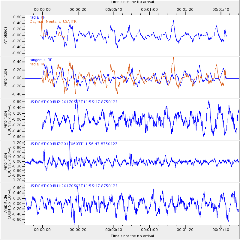
Signal To Noise
| Channel | StoN | STA | LTA |
| US:DGMT:00:BHZ:20170603T11:56:47.875012Z | 3.055764 | 3.064377E-7 | 1.0028186E-7 |
| US:DGMT:00:BH1:20170603T11:56:47.875012Z | 1.1276283 | 1.6000635E-7 | 1.4189635E-7 |
| US:DGMT:00:BH2:20170603T11:56:47.875012Z | 0.7086853 | 1.6605141E-7 | 2.343091E-7 |
| Arrivals |
| Ps | |
| PpPs | |
| PsPs/PpSs | |


