You are here: Home > Network List > TA - USArray Transportable Network (new EarthScope stations) Stations List
> Station H16K Elim, AK, USA > Earthquake Result Viewer
H16K Elim, AK, USA - Earthquake Result Viewer
| Earthquake location: |
Vanuatu Islands |
| Earthquake latitude/longitude: |
-18.7/168.1 |
| Earthquake time(UTC): |
2020/05/27 (148) 07:09:18 GMT |
| Earthquake Depth: |
10 km |
| Earthquake Magnitude: |
6.1 Mww |
| Earthquake Catalog/Contributor: |
NEIC PDE/us |
|
| Network: |
TA USArray Transportable Network (new EarthScope stations) |
| Station: |
H16K Elim, AK, USA |
| Lat/Lon: |
64.64 N/162.24 W |
| Elevation: |
216 m |
|
| Distance: |
86.2 deg |
| Az: |
12.333 deg |
| Baz: |
208.033 deg |
| Ray Param: |
0.04423883 |
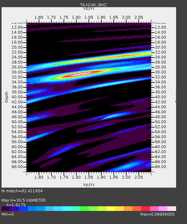
| Estimated Moho Depth: |
30.5 km |
| Estimated Crust Vp/Vs: |
1.82 |
| Assumed Crust Vp: |
6.276 km/s |
| Estimated Crust Vs: |
3.453 km/s |
| Estimated Crust Poisson's Ratio: |
0.28 |
|
| Radial Match: |
92.411804 % |
| Radial Bump: |
400 |
| Transverse Match: |
71.46632 % |
| Transverse Bump: |
400 |
| SOD ConfigId: |
21166931 |
| Insert Time: |
2020-06-10 07:37:32.730 +0000 |
| GWidth: |
2.5 |
| Max Bumps: |
400 |
| Tol: |
0.001 |
|
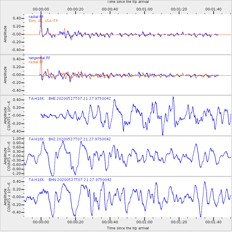
Signal To Noise
| Channel | StoN | STA | LTA |
| TA:H16K: :BHZ:20200527T07:21:27.975004Z | 3.529151 | 5.5006524E-7 | 1.5586332E-7 |
| TA:H16K: :BHN:20200527T07:21:27.975004Z | 2.034271 | 1.392262E-7 | 6.844034E-8 |
| TA:H16K: :BHE:20200527T07:21:27.975004Z | 2.5751827 | 1.341307E-7 | 5.20859E-8 |
| Arrivals |
| Ps | 4.1 SECOND |
| PpPs | 13 SECOND |
| PsPs/PpSs | 17 SECOND |


