You are here: Home > Network List > TA - USArray Transportable Network (new EarthScope stations) Stations List
> Station M14K Bethel, AK, USA > Earthquake Result Viewer
M14K Bethel, AK, USA - Earthquake Result Viewer
| Earthquake location: |
Vanuatu Islands |
| Earthquake latitude/longitude: |
-18.7/168.1 |
| Earthquake time(UTC): |
2020/05/27 (148) 07:09:18 GMT |
| Earthquake Depth: |
10 km |
| Earthquake Magnitude: |
6.1 Mww |
| Earthquake Catalog/Contributor: |
NEIC PDE/us |
|
| Network: |
TA USArray Transportable Network (new EarthScope stations) |
| Station: |
M14K Bethel, AK, USA |
| Lat/Lon: |
60.75 N/161.96 W |
| Elevation: |
19 m |
|
| Distance: |
82.8 deg |
| Az: |
14.302 deg |
| Baz: |
208.47 deg |
| Ray Param: |
0.04663759 |
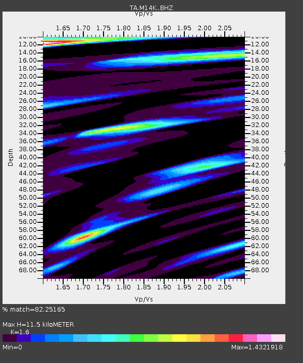
| Estimated Moho Depth: |
11.5 km |
| Estimated Crust Vp/Vs: |
1.60 |
| Assumed Crust Vp: |
6.182 km/s |
| Estimated Crust Vs: |
3.864 km/s |
| Estimated Crust Poisson's Ratio: |
0.18 |
|
| Radial Match: |
82.25165 % |
| Radial Bump: |
400 |
| Transverse Match: |
66.27046 % |
| Transverse Bump: |
400 |
| SOD ConfigId: |
21166931 |
| Insert Time: |
2020-06-10 07:38:08.587 +0000 |
| GWidth: |
2.5 |
| Max Bumps: |
400 |
| Tol: |
0.001 |
|

Signal To Noise
| Channel | StoN | STA | LTA |
| TA:M14K: :BHZ:20200527T07:21:10.949979Z | 4.2096767 | 8.1652746E-7 | 1.9396441E-7 |
| TA:M14K: :BHN:20200527T07:21:10.949979Z | 1.6960622 | 3.3386092E-7 | 1.9684475E-7 |
| TA:M14K: :BHE:20200527T07:21:10.949979Z | 1.1132098 | 2.1151503E-7 | 1.9000464E-7 |
| Arrivals |
| Ps | 1.1 SECOND |
| PpPs | 4.7 SECOND |
| PsPs/PpSs | 5.9 SECOND |


