You are here: Home > Network List > TA - USArray Transportable Network (new EarthScope stations) Stations List
> Station O17K Koliganek, Bristol Bay, AK, USA > Earthquake Result Viewer
O17K Koliganek, Bristol Bay, AK, USA - Earthquake Result Viewer
| Earthquake location: |
Vanuatu Islands |
| Earthquake latitude/longitude: |
-18.7/168.1 |
| Earthquake time(UTC): |
2020/05/27 (148) 07:09:18 GMT |
| Earthquake Depth: |
10 km |
| Earthquake Magnitude: |
6.1 Mww |
| Earthquake Catalog/Contributor: |
NEIC PDE/us |
|
| Network: |
TA USArray Transportable Network (new EarthScope stations) |
| Station: |
O17K Koliganek, Bristol Bay, AK, USA |
| Lat/Lon: |
59.77 N/157.09 W |
| Elevation: |
156 m |
|
| Distance: |
83.2 deg |
| Az: |
16.907 deg |
| Baz: |
213.006 deg |
| Ray Param: |
0.046356633 |
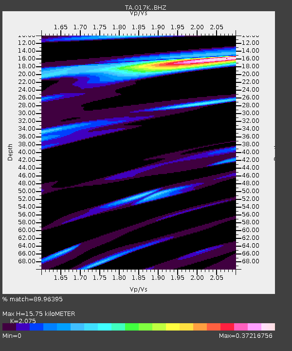
| Estimated Moho Depth: |
15.75 km |
| Estimated Crust Vp/Vs: |
2.08 |
| Assumed Crust Vp: |
6.276 km/s |
| Estimated Crust Vs: |
3.024 km/s |
| Estimated Crust Poisson's Ratio: |
0.35 |
|
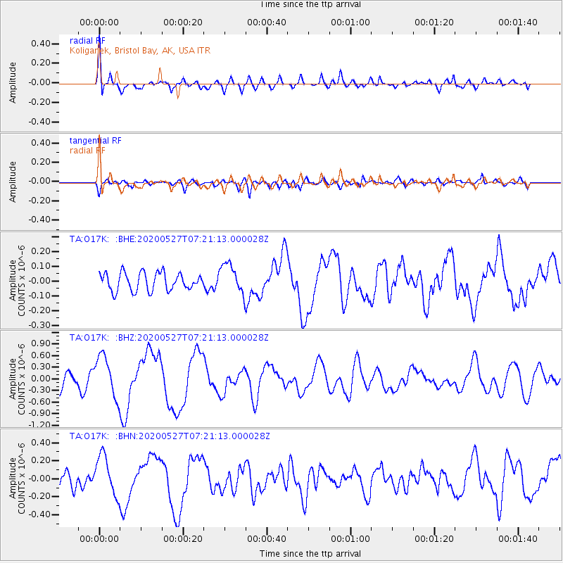
| Radial Match: |
89.96395 % |
| Radial Bump: |
400 |
| Transverse Match: |
69.63808 % |
| Transverse Bump: |
400 |
| SOD ConfigId: |
21166931 |
| Insert Time: |
2020-06-10 07:38:36.291 +0000 |
| GWidth: |
2.5 |
| Max Bumps: |
400 |
| Tol: |
0.001 |
|
Signal To Noise
| Channel | StoN | STA | LTA |
| TA:O17K: :BHZ:20200527T07:21:13.000028Z | 3.7367592 | 5.5090715E-7 | 1.4742913E-7 |
| TA:O17K: :BHN:20200527T07:21:13.000028Z | 2.0993116 | 2.3066687E-7 | 1.0987739E-7 |
| TA:O17K: :BHE:20200527T07:21:13.000028Z | 1.7204186 | 1.0325796E-7 | 6.001909E-8 |
| Arrivals |
| Ps | 2.8 SECOND |
| PpPs | 7.6 SECOND |
| PsPs/PpSs | 10 SECOND |


