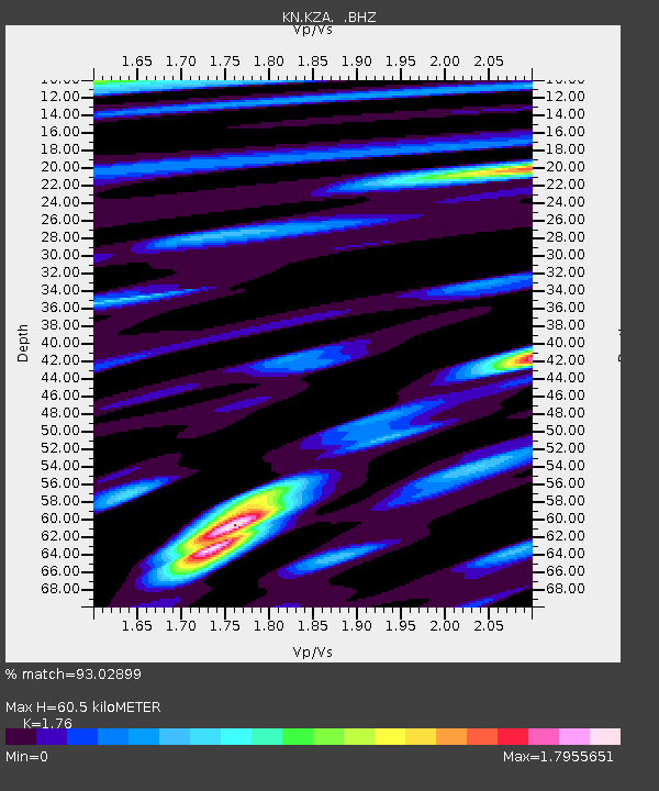
KZA KN.KZA - Earthquake Result Viewer
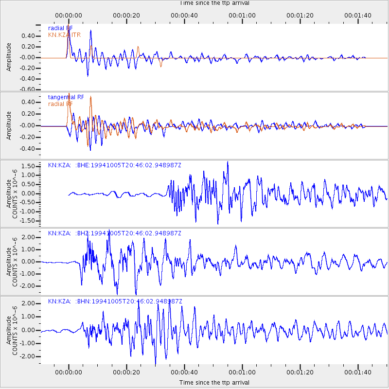
Earthquake location: Kuril Islands
Earthquake latitude/longitude: 43.5/147.5
Earthquake time(UTC): 1994/10/05 (278) 20:37:31 GMT
Earthquake Depth: 33 km
Earthquake Magnitude: 5.7 MB, 5.9 MS, 5.9 UNKNOWN, 5.9 MW
Earthquake Catalog/Contributor: WHDF/NEIC
Network: KN Kyrgyz Seismic Telemetry Network
Station: KZA KN.KZA
Lat/Lon: 42.08 N/75.25 E
Elevation: 3520 m
Distance: 51.4 deg
Az: 294.921 deg
Baz: 62.351 deg
Ray Param: 0.067369334
Estimated Moho Depth: 60.5 km
Estimated Crust Vp/Vs: 1.76
Assumed Crust Vp: 6.306 km/s
Estimated Crust Vs: 3.583 km/s
Estimated Crust Poisson's Ratio: 0.26
Radial Match: 93.02899 %
Radial Bump: 400
Transverse Match: 90.241394 %
Transverse Bump: 400
SOD ConfigId: 4480
Insert Time: 2010-03-08 20:25:21.006 +0000
GWidth: 2.5
Max Bumps: 400
Tol: 0.001

Signal To Noise

ChannelStoNSTALTA
KN:KZA: :BHZ:19941005T20:46:02.948987Z9.5120054.8931156E-75.1441475E-8
KN:KZA: :BHN:19941005T20:46:02.948987Z2.65434742.0738968E-77.8132075E-8
KN:KZA: :BHE:19941005T20:46:02.948987Z1.92820451.4431086E-77.484209E-8
Arrivals
Ps7.7 SECOND
PpPs25 SECOND
PsPs/PpSs33 SECOND