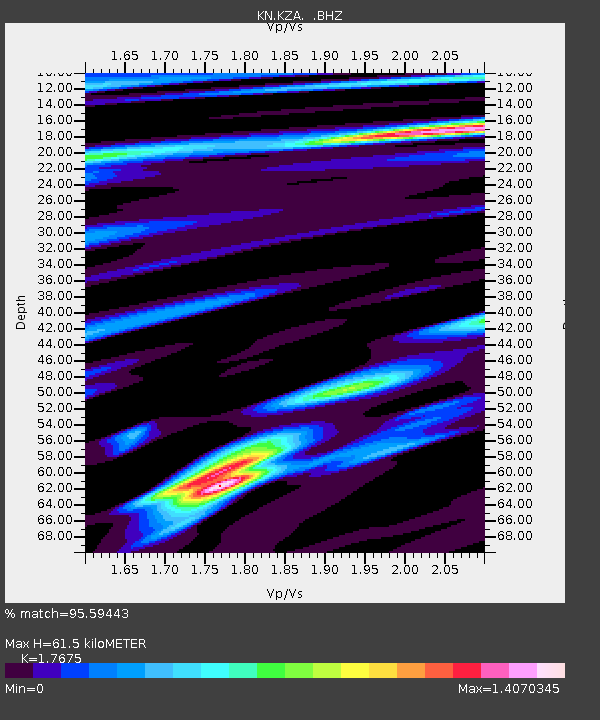
KZA KN.KZA - Earthquake Result Viewer

Earthquake location: Kuril Islands
Earthquake latitude/longitude: 43.9/147.9
Earthquake time(UTC): 1994/10/09 (282) 07:55:38 GMT
Earthquake Depth: 23 km
Earthquake Magnitude: 6.5 MB, 7.0 MS, 6.7 UNKNOWN, 7.3 MW
Earthquake Catalog/Contributor: WHDF/NEIC
Network: KN Kyrgyz Seismic Telemetry Network
Station: KZA KN.KZA
Lat/Lon: 42.08 N/75.25 E
Elevation: 3520 m
Distance: 51.6 deg
Az: 294.862 deg
Baz: 61.765 deg
Ray Param: 0.06730466
Estimated Moho Depth: 61.5 km
Estimated Crust Vp/Vs: 1.77
Assumed Crust Vp: 6.306 km/s
Estimated Crust Vs: 3.568 km/s
Estimated Crust Poisson's Ratio: 0.26
Radial Match: 95.59443 %
Radial Bump: 400
Transverse Match: 91.084816 %
Transverse Bump: 400
SOD ConfigId: 4480
Insert Time: 2010-03-08 20:25:29.326 +0000
GWidth: 2.5
Max Bumps: 400
Tol: 0.001

Signal To Noise

ChannelStoNSTALTA
KN:KZA: :BHZ:19941009T08:04:11.250Z10.4287691.3256227E-61.271121E-7
KN:KZA: :BHN:19941009T08:04:11.250Z1.99700691.9854464E-79.942111E-8
KN:KZA: :BHE:19941009T08:04:11.250Z2.14951063.7706963E-71.7542115E-7
Arrivals
Ps7.9 SECOND
PpPs26 SECOND
PsPs/PpSs33 SECOND