You are here: Home > Network List > KN - Kyrgyz Seismic Telemetry Network Stations List
> Station KZA KN.KZA > Earthquake Result Viewer
KZA KN.KZA - Earthquake Result Viewer
| Earthquake location: |
Kuril Islands |
| Earthquake latitude/longitude: |
43.6/147.1 |
| Earthquake time(UTC): |
1994/10/18 (291) 17:12:51 GMT |
| Earthquake Depth: |
66 km |
| Earthquake Magnitude: |
6.1 MB, 6.1 UNKNOWN, 5.9 MW |
| Earthquake Catalog/Contributor: |
WHDF/NEIC |
|
| Network: |
KN Kyrgyz Seismic Telemetry Network |
| Station: |
KZA KN.KZA |
| Lat/Lon: |
42.08 N/75.25 E |
| Elevation: |
3520 m |
|
| Distance: |
51.2 deg |
| Az: |
294.765 deg |
| Baz: |
62.471 deg |
| Ray Param: |
0.06739219 |
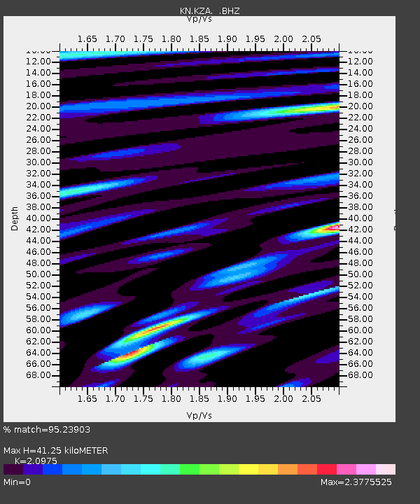
| Estimated Moho Depth: |
41.25 km |
| Estimated Crust Vp/Vs: |
2.10 |
| Assumed Crust Vp: |
6.306 km/s |
| Estimated Crust Vs: |
3.006 km/s |
| Estimated Crust Poisson's Ratio: |
0.35 |
|
| Radial Match: |
95.23903 % |
| Radial Bump: |
400 |
| Transverse Match: |
92.35417 % |
| Transverse Bump: |
400 |
| SOD ConfigId: |
4480 |
| Insert Time: |
2010-03-08 20:25:41.053 +0000 |
| GWidth: |
2.5 |
| Max Bumps: |
400 |
| Tol: |
0.001 |
|

Signal To Noise
| Channel | StoN | STA | LTA |
| KN:KZA: :BHZ:19941018T17:21:17.400Z | 35.575813 | 2.7343501E-6 | 7.6859806E-8 |
| KN:KZA: :BHN:19941018T17:21:17.400Z | 5.2902884 | 5.400442E-7 | 1.0208218E-7 |
| KN:KZA: :BHE:19941018T17:21:17.400Z | 15.144035 | 7.5873334E-7 | 5.0101136E-8 |
| Arrivals |
| Ps | 7.5 SECOND |
| PpPs | 19 SECOND |
| PsPs/PpSs | 27 SECOND |


