You are here: Home > Network List > KN - Kyrgyz Seismic Telemetry Network Stations List
> Station KZA KN.KZA > Earthquake Result Viewer
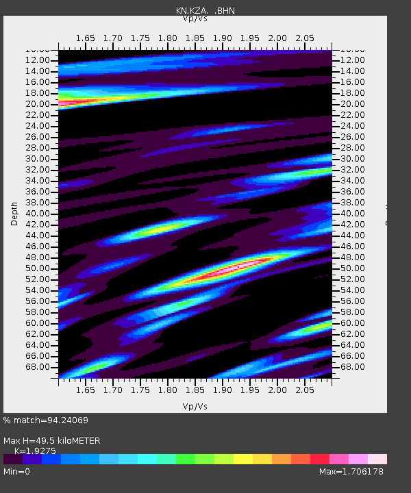
KZA KN.KZA - Earthquake Result Viewer
| Earthquake location: |
Java, Indonesia |
| Earthquake latitude/longitude: |
-8.2/112.4 |
| Earthquake time(UTC): |
1998/09/28 (271) 13:34:30 GMT |
| Earthquake Depth: |
152 km |
| Earthquake Magnitude: |
6.4 MB, 6.5 UNKNOWN, 6.5 MW |
| Earthquake Catalog/Contributor: |
WHDF/NEIC |
|
| Network: |
KN Kyrgyz Seismic Telemetry Network |
| Station: |
KZA KN.KZA |
| Lat/Lon: |
42.08 N/75.25 E |
| Elevation: |
3520 m |
|
| Distance: |
60.5 deg |
| Az: |
328.88 deg |
| Baz: |
136.588 deg |
| Ray Param: |
0.061038062 |
| Estimated Moho Depth: |
49.5 km |
| Estimated Crust Vp/Vs: |
1.93 |
| Assumed Crust Vp: |
6.306 km/s |
| Estimated Crust Vs: |
3.272 km/s |
| Estimated Crust Poisson's Ratio: |
0.32 |
|
| Radial Match: |
94.24069 % |
| Radial Bump: |
400 |
| Transverse Match: |
87.46125 % |
| Transverse Bump: |
400 |
| SOD ConfigId: |
4480 |
| Insert Time: |
2010-03-08 20:25:46.292 +0000 |
| GWidth: |
2.5 |
| Max Bumps: |
400 |
| Tol: |
0.001 |
|

Signal To Noise
| Channel | StoN | STA | LTA |
| KN:KZA: :BHN:19980928T13:43:53.449011Z | 32.765022 | 2.9280393E-6 | 8.936479E-8 |
| KN:KZA: :BHE:19980928T13:43:53.449011Z | 10.905016 | 1.3275979E-6 | 1.2174195E-7 |
| KN:KZA: :BHZ:19980928T13:43:53.449011Z | 7.6142044 | 7.7514795E-7 | 1.0180288E-7 |
| Arrivals |
| Ps | 7.6 SECOND |
| PpPs | 22 SECOND |
| PsPs/PpSs | 30 SECOND |


