You are here: Home > Network List > KN - Kyrgyz Seismic Telemetry Network Stations List
> Station KZA KN.KZA > Earthquake Result Viewer
KZA KN.KZA - Earthquake Result Viewer

| Earthquake location: |
Banda Sea |
| Earthquake latitude/longitude: |
-7.0/129.0 |
| Earthquake time(UTC): |
1998/11/09 (313) 05:30:14 GMT |
| Earthquake Depth: |
33 km |
| Earthquake Magnitude: |
6.1 MB, 6.7 UNKNOWN, 6.6 ME |
| Earthquake Catalog/Contributor: |
WHDF/NEIC |
|
| Network: |
KN Kyrgyz Seismic Telemetry Network |
| Station: |
KZA KN.KZA |
| Lat/Lon: |
42.08 N/75.25 E |
| Elevation: |
3520 m |
|
| Distance: |
69.1 deg |
| Az: |
320.001 deg |
| Baz: |
121.004 deg |
| Ray Param: |
0.055810172 |
| Estimated Moho Depth: |
19.25 km |
| Estimated Crust Vp/Vs: |
1.60 |
| Assumed Crust Vp: |
6.306 km/s |
| Estimated Crust Vs: |
3.941 km/s |
| Estimated Crust Poisson's Ratio: |
0.18 |
|
| Radial Match: |
95.68694 % |
| Radial Bump: |
400 |
| Transverse Match: |
93.50238 % |
| Transverse Bump: |
400 |
| SOD ConfigId: |
4480 |
| Insert Time: |
2010-03-08 20:26:06.676 +0000 |
| GWidth: |
2.5 |
| Max Bumps: |
400 |
| Tol: |
0.001 |
|
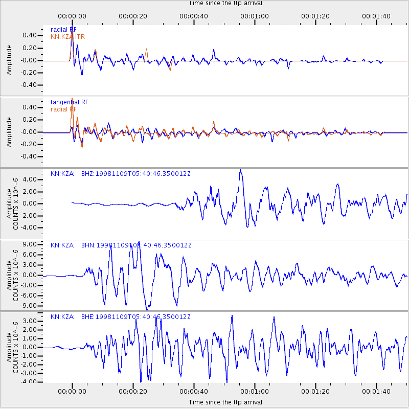
Signal To Noise
| Channel | StoN | STA | LTA |
| KN:KZA: :BHN:19981109T05:40:46.350012Z | 9.474287 | 5.0866066E-7 | 5.3688538E-8 |
| KN:KZA: :BHE:19981109T05:40:46.350012Z | 0.91602105 | 1.5689585E-7 | 1.7127974E-7 |
| KN:KZA: :BHZ:19981109T05:40:46.350012Z | 1.3140469 | 1.6986286E-7 | 1.2926697E-7 |
| Arrivals |
| Ps | 1.9 SECOND |
| PpPs | 7.6 SECOND |
| PsPs/PpSs | 9.5 SECOND |


