You are here: Home > Network List > AV - Alaska Volcano Observatory Stations List
> Station AUSS Augustine Summit Station, Augustine Volcano, Alaska > Earthquake Result Viewer
AUSS Augustine Summit Station, Augustine Volcano, Alaska - Earthquake Result Viewer
| Earthquake location: |
Tonga Islands Region |
| Earthquake latitude/longitude: |
-22.2/-174.3 |
| Earthquake time(UTC): |
2020/05/28 (149) 07:18:44 GMT |
| Earthquake Depth: |
10 km |
| Earthquake Magnitude: |
5.9 mww |
| Earthquake Catalog/Contributor: |
NEIC PDE/us |
|
| Network: |
AV Alaska Volcano Observatory |
| Station: |
AUSS Augustine Summit Station, Augustine Volcano, Alaska |
| Lat/Lon: |
59.36 N/153.43 W |
| Elevation: |
1235 m |
|
| Distance: |
83.1 deg |
| Az: |
10.584 deg |
| Baz: |
199.405 deg |
| Ray Param: |
0.046437025 |
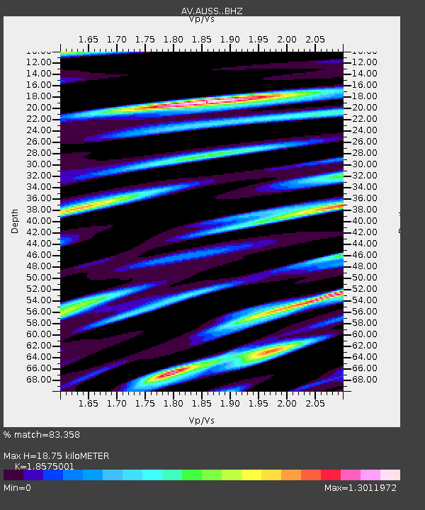
| Estimated Moho Depth: |
18.75 km |
| Estimated Crust Vp/Vs: |
1.86 |
| Assumed Crust Vp: |
5.989 km/s |
| Estimated Crust Vs: |
3.224 km/s |
| Estimated Crust Poisson's Ratio: |
0.30 |
|
| Radial Match: |
83.358 % |
| Radial Bump: |
400 |
| Transverse Match: |
83.34428 % |
| Transverse Bump: |
300 |
| SOD ConfigId: |
21166931 |
| Insert Time: |
2020-06-11 07:24:15.718 +0000 |
| GWidth: |
2.5 |
| Max Bumps: |
400 |
| Tol: |
0.001 |
|

Signal To Noise
| Channel | StoN | STA | LTA |
| AV:AUSS: :BHZ:20200528T07:30:39.159983Z | 13.821637 | 2.5977438E-6 | 1.879476E-7 |
| AV:AUSS: :BHN:20200528T07:30:39.159983Z | 2.7034795 | 1.3393641E-6 | 4.954223E-7 |
| AV:AUSS: :BHE:20200528T07:30:39.159983Z | 1.5847545 | 6.6712795E-7 | 4.209661E-7 |
| Arrivals |
| Ps | 2.7 SECOND |
| PpPs | 8.8 SECOND |
| PsPs/PpSs | 11 SECOND |


