You are here: Home > Network List > AV - Alaska Volcano Observatory Stations List
> Station PLBL Mt. Peulik Volcano, Alaska > Earthquake Result Viewer
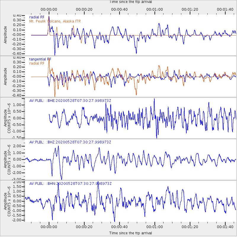
PLBL Mt. Peulik Volcano, Alaska - Earthquake Result Viewer
*The percent match for this event was below the threshold and hence no stack was calculated.
| Earthquake location: |
Tonga Islands Region |
| Earthquake latitude/longitude: |
-22.2/-174.3 |
| Earthquake time(UTC): |
2020/05/28 (149) 07:18:44 GMT |
| Earthquake Depth: |
10 km |
| Earthquake Magnitude: |
5.9 mww |
| Earthquake Catalog/Contributor: |
NEIC PDE/us |
|
| Network: |
AV Alaska Volcano Observatory |
| Station: |
PLBL Mt. Peulik Volcano, Alaska |
| Lat/Lon: |
57.70 N/156.82 W |
| Elevation: |
461 m |
|
| Distance: |
81.0 deg |
| Az: |
9.391 deg |
| Baz: |
196.353 deg |
| Ray Param: |
$rayparam |
*The percent match for this event was below the threshold and hence was not used in the summary stack. |
|
| Radial Match: |
74.412636 % |
| Radial Bump: |
400 |
| Transverse Match: |
57.668888 % |
| Transverse Bump: |
400 |
| SOD ConfigId: |
21166931 |
| Insert Time: |
2020-06-11 07:25:00.343 +0000 |
| GWidth: |
2.5 |
| Max Bumps: |
400 |
| Tol: |
0.001 |
|
Signal To Noise
| Channel | StoN | STA | LTA |
| AV:PLBL: :BHZ:20200528T07:30:27.998973Z | 4.740413 | 9.870614E-7 | 2.0822266E-7 |
| AV:PLBL: :BHN:20200528T07:30:27.998973Z | 2.4454048 | 6.8804366E-7 | 2.8136188E-7 |
| AV:PLBL: :BHE:20200528T07:30:27.998973Z | 1.3059444 | 4.860468E-7 | 3.7218032E-7 |
| Arrivals |
| Ps | |
| PpPs | |
| PsPs/PpSs | |


