You are here: Home > Network List > TS - TERRAscope (Southern California Seismic Network) Stations List
> Station SNCC San Nicolas Island, California, USA > Earthquake Result Viewer
SNCC San Nicolas Island, California, USA - Earthquake Result Viewer
| Earthquake location: |
Northern Peru |
| Earthquake latitude/longitude: |
-3.9/-77.0 |
| Earthquake time(UTC): |
1995/05/02 (122) 06:06:05 GMT |
| Earthquake Depth: |
103 km |
| Earthquake Magnitude: |
6.5 MB, 6.7 UNKNOWN, 6.6 MW |
| Earthquake Catalog/Contributor: |
WHDF/NEIC |
|
| Network: |
TS TERRAscope (Southern California Seismic Network) |
| Station: |
SNCC San Nicolas Island, California, USA |
| Lat/Lon: |
33.25 N/119.52 W |
| Elevation: |
227 m |
|
| Distance: |
54.6 deg |
| Az: |
315.936 deg |
| Baz: |
124.099 deg |
| Ray Param: |
0.065030836 |
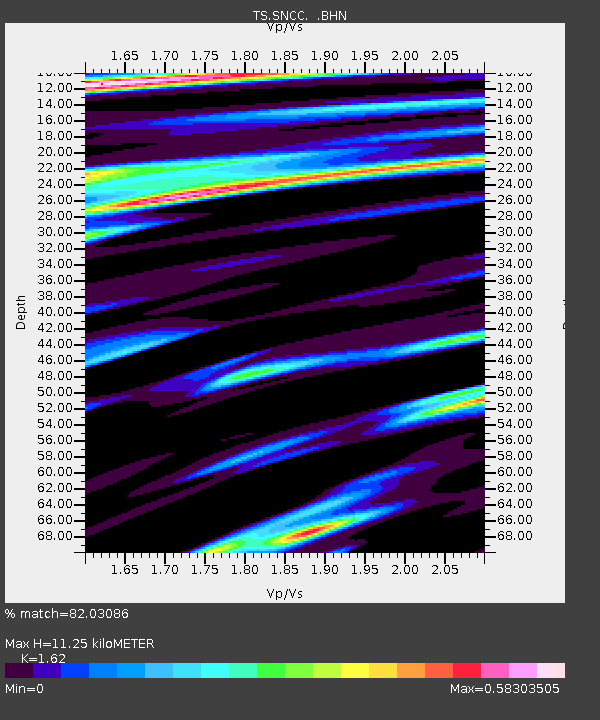
| Estimated Moho Depth: |
11.25 km |
| Estimated Crust Vp/Vs: |
1.62 |
| Assumed Crust Vp: |
6.048 km/s |
| Estimated Crust Vs: |
3.733 km/s |
| Estimated Crust Poisson's Ratio: |
0.19 |
|
| Radial Match: |
82.03086 % |
| Radial Bump: |
400 |
| Transverse Match: |
72.87032 % |
| Transverse Bump: |
400 |
| SOD ConfigId: |
6273 |
| Insert Time: |
2010-02-26 14:51:28.101 +0000 |
| GWidth: |
2.5 |
| Max Bumps: |
400 |
| Tol: |
0.001 |
|

Signal To Noise
| Channel | StoN | STA | LTA |
| TS:SNCC: :BHN:19950502T06:14:53.105017Z | 1.0781213 | 6.7546665E-7 | 6.2652197E-7 |
| TS:SNCC: :BHE:19950502T06:14:53.105017Z | 2.822423 | 1.4440134E-6 | 5.1162186E-7 |
| TS:SNCC: :BHZ:19950502T06:14:53.105017Z | 19.300028 | 3.7159487E-6 | 1.9253594E-7 |
| Arrivals |
| Ps | 1.2 SECOND |
| PpPs | 4.6 SECOND |
| PsPs/PpSs | 5.8 SECOND |


