You are here: Home > Network List > CI - Caltech Regional Seismic Network Stations List
> Station MLAC Mammoth Lakes, California, USA > Earthquake Result Viewer
MLAC Mammoth Lakes, California, USA - Earthquake Result Viewer

| Earthquake location: |
Tonga Islands Region |
| Earthquake latitude/longitude: |
-22.2/-174.3 |
| Earthquake time(UTC): |
2020/05/28 (149) 07:18:44 GMT |
| Earthquake Depth: |
10 km |
| Earthquake Magnitude: |
5.9 mww |
| Earthquake Catalog/Contributor: |
NEIC PDE/us |
|
| Network: |
CI Caltech Regional Seismic Network |
| Station: |
MLAC Mammoth Lakes, California, USA |
| Lat/Lon: |
37.63 N/118.84 W |
| Elevation: |
2134 m |
|
| Distance: |
79.1 deg |
| Az: |
41.747 deg |
| Baz: |
230.989 deg |
| Ray Param: |
0.049171343 |
| Estimated Moho Depth: |
46.0 km |
| Estimated Crust Vp/Vs: |
1.66 |
| Assumed Crust Vp: |
6.291 km/s |
| Estimated Crust Vs: |
3.784 km/s |
| Estimated Crust Poisson's Ratio: |
0.22 |
|
| Radial Match: |
80.77696 % |
| Radial Bump: |
400 |
| Transverse Match: |
76.01171 % |
| Transverse Bump: |
400 |
| SOD ConfigId: |
21166931 |
| Insert Time: |
2020-06-11 07:29:33.839 +0000 |
| GWidth: |
2.5 |
| Max Bumps: |
400 |
| Tol: |
0.001 |
|
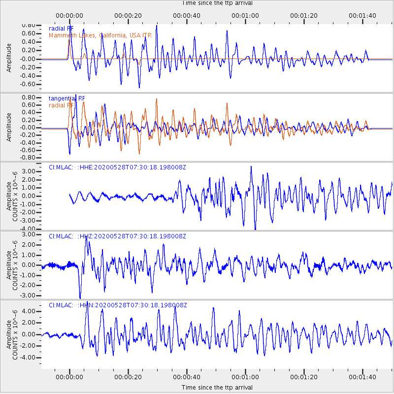
Signal To Noise
| Channel | StoN | STA | LTA |
| CI:MLAC: :HHZ:20200528T07:30:18.198008Z | 8.080216 | 1.0368263E-6 | 1.2831666E-7 |
| CI:MLAC: :HHN:20200528T07:30:18.198008Z | 2.6427236 | 7.1764055E-7 | 2.7155338E-7 |
| CI:MLAC: :HHE:20200528T07:30:18.198008Z | 0.7239673 | 2.1751443E-7 | 3.0044785E-7 |
| Arrivals |
| Ps | 5.0 SECOND |
| PpPs | 19 SECOND |
| PsPs/PpSs | 24 SECOND |


