You are here: Home > Network List > TS - TERRAscope (Southern California Seismic Network) Stations List
> Station SNCC San Nicolas Island, California, USA > Earthquake Result Viewer
SNCC San Nicolas Island, California, USA - Earthquake Result Viewer
| Earthquake location: |
Mariana Islands |
| Earthquake latitude/longitude: |
18.9/145.2 |
| Earthquake time(UTC): |
1995/08/23 (235) 07:06:02 GMT |
| Earthquake Depth: |
596 km |
| Earthquake Magnitude: |
6.3 MB, 6.3 UNKNOWN, 7.0 MW |
| Earthquake Catalog/Contributor: |
WHDF/NEIC |
|
| Network: |
TS TERRAscope (Southern California Seismic Network) |
| Station: |
SNCC San Nicolas Island, California, USA |
| Lat/Lon: |
33.25 N/119.52 W |
| Elevation: |
227 m |
|
| Distance: |
84.1 deg |
| Az: |
57.014 deg |
| Baz: |
288.574 deg |
| Ray Param: |
0.043934617 |
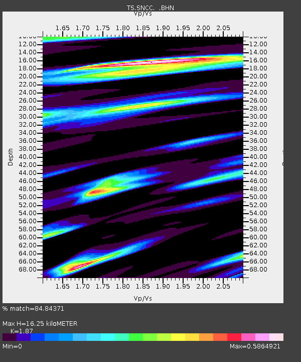
| Estimated Moho Depth: |
16.25 km |
| Estimated Crust Vp/Vs: |
1.87 |
| Assumed Crust Vp: |
6.048 km/s |
| Estimated Crust Vs: |
3.234 km/s |
| Estimated Crust Poisson's Ratio: |
0.30 |
|
| Radial Match: |
84.84371 % |
| Radial Bump: |
400 |
| Transverse Match: |
78.22973 % |
| Transverse Bump: |
400 |
| SOD ConfigId: |
6273 |
| Insert Time: |
2010-02-26 14:51:32.224 +0000 |
| GWidth: |
2.5 |
| Max Bumps: |
400 |
| Tol: |
0.001 |
|
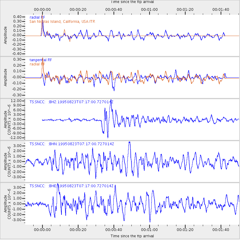
Signal To Noise
| Channel | StoN | STA | LTA |
| TS:SNCC: :BHN:19950823T07:17:00.727014Z | 1.6677504 | 4.6128517E-7 | 2.7659127E-7 |
| TS:SNCC: :BHE:19950823T07:17:00.727014Z | 2.6590135 | 7.879637E-7 | 2.9633685E-7 |
| TS:SNCC: :BHZ:19950823T07:17:00.727014Z | 10.408095 | 3.5429657E-6 | 3.404048E-7 |
| Arrivals |
| Ps | 2.4 SECOND |
| PpPs | 7.6 SECOND |
| PsPs/PpSs | 9.9 SECOND |


