You are here: Home > Network List > TS - TERRAscope (Southern California Seismic Network) Stations List
> Station SNCC San Nicolas Island, California, USA > Earthquake Result Viewer
SNCC San Nicolas Island, California, USA - Earthquake Result Viewer

| Earthquake location: |
Near Coast Of Nicaragua |
| Earthquake latitude/longitude: |
11.8/-87.9 |
| Earthquake time(UTC): |
1996/03/27 (087) 20:52:06 GMT |
| Earthquake Depth: |
33 km |
| Earthquake Magnitude: |
5.5 MB, 5.5 MS, 5.9 UNKNOWN, 5.4 MS |
| Earthquake Catalog/Contributor: |
WHDF/NEIC |
|
| Network: |
TS TERRAscope (Southern California Seismic Network) |
| Station: |
SNCC San Nicolas Island, California, USA |
| Lat/Lon: |
33.25 N/119.52 W |
| Elevation: |
227 m |
|
| Distance: |
35.9 deg |
| Az: |
311.59 deg |
| Baz: |
119.078 deg |
| Ray Param: |
0.076891266 |
| Estimated Moho Depth: |
17.75 km |
| Estimated Crust Vp/Vs: |
1.88 |
| Assumed Crust Vp: |
6.048 km/s |
| Estimated Crust Vs: |
3.213 km/s |
| Estimated Crust Poisson's Ratio: |
0.30 |
|
| Radial Match: |
82.56585 % |
| Radial Bump: |
335 |
| Transverse Match: |
77.2355 % |
| Transverse Bump: |
309 |
| SOD ConfigId: |
9875 |
| Insert Time: |
2010-02-26 14:51:33.411 +0000 |
| GWidth: |
2.5 |
| Max Bumps: |
400 |
| Tol: |
0.001 |
|
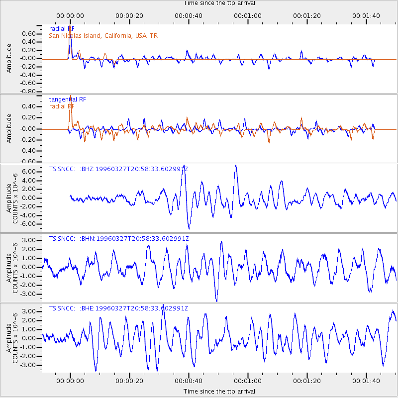
Signal To Noise
| Channel | StoN | STA | LTA |
| TS:SNCC: :BHN:19960327T20:58:33.602991Z | 1.9829226 | 8.3724416E-7 | 4.2222737E-7 |
| TS:SNCC: :BHE:19960327T20:58:33.602991Z | 1.1107131 | 6.101808E-7 | 5.4935947E-7 |
| TS:SNCC: :BHZ:19960327T20:58:33.602991Z | 2.665585 | 1.8190187E-6 | 6.8240877E-7 |
| Arrivals |
| Ps | 2.8 SECOND |
| PpPs | 8.0 SECOND |
| PsPs/PpSs | 11 SECOND |


